Pagasa: LPA unlikely to turn into tropical depression but may bring rain
MANILA, Philippines — The low-pressure area (LPA) near Catanduanes is not expected to intensify into a tropical depression, but state meteorologists said Tuesday it may trigger the return of monsoon rains in the country.
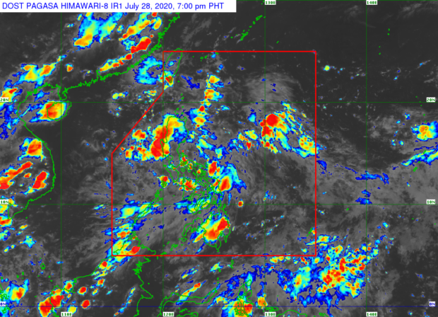
The Philippine Atmospheric, Geophysical and Astronomical Services Administration (Pagasa) forecast at 5:00 p.m. showed the LPA moved nearer the Bicol Region’s landmass, as it is last spotted 65 kilometers east northeast of Virac.
The LPA is expected to bring rains in the said region, including parts of Southern Luzon and the Visayas, while it may also cause the return of the southwest monsoon or “Habagat”, which has been quite dormant after succeeding to monsoon breaks.
“Nananatili pa rin na mababa ang tsansa na maging isang ganap na bagyo ito sa susunod na isa o dalawang araw, pero nakikita natin na patuloy pa rin itong magdudulot ng pag-ulan sa iba’t ibang bahagi ng ating bansa,” weather specialist Robb Gile said.
(There is still a low chance that the LPA would develop into a storm in the next one to two days, but we see that this would continue on bringing rains to various parts of the country.)
Article continues after this advertisement“Posibleng ang low pressure area na ito ang siyang mag-trigger ng pagbabalik ng ating Hanging Habagat o southwest monsoon. Kaya tignan natin kung ano ‘yong mararanasan anting lagay ng panahon sa magdamag,” he added.
Article continues after this advertisement(It is possible that the low-pressure area will trigger the return of the southwest monsoon, that is why we would be monitoring the weather situation overnight.)
Aside from the above-mentioned areas, parts of Luzon will also see rain on Tuesday night largely due to the trough of the LPA, which will affect Central Luzon, Northern Luzon, and Cordillera.
Visayas and Mindanao, on the other hand, would also see thunderstorms as the initial wind system from the Habagat and the circulation of the LPA meet, bringing rains in the said region.
Pagasa advised residents of the said provinces to monitor updates on their social media sites for possible rainfall and thunderstorm advisories.
Weather is expected to be generally cool on Wednesday due to rains and cloudy weather, with temperatures in Metro Manila ranging from 24°C to 30°C, Laoag and Tuguegarao from 24°C to 32°C, and Tagaytay City from 21°C to 28°C.
The same could be expected for Visayas and Mindanao with temperatures forecast to range from 24°C to 30°C in Tacloban, 25°C to 31°C in Cebu, 23°C o 31°C in Cagayan de Oro, and 25°C to 32°C in Davao.
The rainy and cold weather is expected to persist in Metro Manila and Cebu until Saturday, according to Pagasa, while fair weather may be experienced in Davao by the weekend.
No gale warning has been raised as of now, although Pagasa warned seafarers and fisherfolk using small boats that sea conditions in various parts of the country may vary from just slight to moderate, to moderate to rough during thunderstorms.