MANILA, Philippines — Tropical depression Carina will bring scattered light to moderate rains with at times heavy rainshowers to Batanes, Babuyan Islands, Ilocos Norte, Ilocos Sur, and Abra on Tuesday, according to the Philippine Atmospheric, Geophysical, and Astronomical Services Administration.
In its 5 a.m. forecast, Pagasa warned that flooding and rain-induced landslides may occur during heavy or prolonged rainfall especially in areas highly susceptible to these hazards.
Pagasa said the center of “Carina” was last spotted 35 kilometers west southwest of Basco, Batanes. By tomorrow morning, it is expected to be located 260 kilometers north northwest of Basco.
The weather disturbance has maximum sustained winds of 45 kph near the center and gustiness of up to 55 kph.
“Tropical Depression Carina is forecast to turn northward as it passes near Batanes. It is forecast to weaken into a low pressure area today or tomorrow morning,” added the weather bureau.
Tropical Cyclone Wind Signal (TCWS) No. 1 remains raised over Batanes and Babuyan Islands.
Areas under TCWS No. 1 will experience winds of 30 to 60 kilometers per hour (kph) in at least 36 hours or intermittent rain within 36 hours.
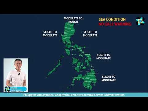
Moderate to rough seas will be experienced over the seaboards of Northern Luzon in the next 24 hours. Those with small seacrafts are advised not to venture out to sea.
RELATED STORY
‘Carina’ keeps strength as it moves north; landfall still a possibility