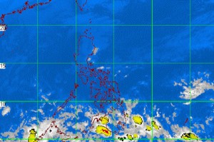
MTSAT ENHANCED IR Satellite Image
MANILA, Philippines—A low pressure area off General Santos City threatens to bring heavy rain over Mindanao, but has little chance of intensifying into a tropical depression, weather forecasters said Tuesday.
The LPA was spotted 550 kilometers east southeast of General Santos City, the Philippine Atmospheric, Geophysical and Astronomical Services Administration said in its 5 p.m. bulletin Tuesday.
Forecaster Fernando Cada said the LPA would blanket Eastern Visayas and Mindanao with cloudy skies coupled with scattered rain showers and thunderstorms.
Cada said widespread rains that could spawn flash floods and landslides could hit Eastern and Southern Mindanao.
The weather system was forecast to dump 10 millimeters of rainfall, equivalent to heavy rainfall. It, however, has a slim chance of intensifying into a tropical depression because its “cloudiness is distorted and it has lost its circulation,’’ Cada said.
“Based on climate models, there’s a small probability that it will form into a tropical depression,’’ he said by phone.”It might dissipate.’’
This LPA was different from the LPA that developed east southeast of General Santos last Saturday and later dissolved.
LPAs have been developing over Mindanao because of the convergence of the northeast monsoon with the winds from the east, forming cloudiness that drifts southward toward the area.
Meanwhile, the northeast monsoon would bring cloudy skies with rain showers and thunderstorms over eastern Visayas, and partly cloudy to cloudy skies with isolated rain showers and thunderstorms over Luzon, including Metro Manila.