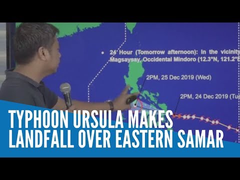
Typhoon Ursula makes landfall over Eastern Samar

MANILA, Philippines — Christmas Typhoon Ursula (international name: Phanfone) made landfall over Eastern Samar late afternoon Tuesday.
In its latest update, the Philippine Atmospheric, Geophysical, and Astronomical Services Administration (Pagasa) said Ursula hit Salcedo, Eastern Samar, at 4:45 p.m.
https://www.facebook.com/302746419835274/posts/2517648385011722/?d=n
Pagasa also said the weather disturbance is moving faster in the west direction from 20 kilometers per hour to 25 kilometers per hour even as it maintained its maximum sustained winds of up to 120 kilometers kph near the center and gustiness of up to 150 kph.
The state weather bureau said Ursula’s eyewall is bringing violent winds at this time over the southern portion of Eastern Samar, and it is likely to affect Biliran, southern portion of Samar, and northern portion of Leyte in the next few hours.
From now until Wednesday noon, expect Ursula to bring sporadic to frequent heavy rains over Dinagat Islands, Siargao and Bucas Grande Islands, Eastern Visayas, Sorsogon, Masbate, northern and central Cebu, northern Negros Provinces, Aklan, Antique, Capiz, Iloilo, Guimaras, and Romblon, according to Pagasa.
The rest of Bicol Region, Quezon, Marinduque, Oriental Mindoro, and the rest of Visayas and Surigao del Norte may likely experience light to moderate with intermittent heavy rains during the same period, Pagasa noted.
Likewise, Pagasa said Ursula would cause occasional to frequent heavy rains in Aklan, Antique, Capiz, Romblon, Marinduque, Oriental Mindoro, Occidental Mindoro, Batangas, and Calamian Islands between noon and late evening Wednesday.
Similarly, during the same period, light to moderate with intermittent heavy rains may prevail over Cuyo Islands, Negros Provinces, Iloilo, Guimaras, Aurora, and the rest of Calabarzon, Pagasa said.
The state weather bureau advised residents in the affected areas to take measures that would reduce the potential flooding and landslides because of Ursula.
According to Pagasa, moderate to strong winds will begin affecting the Bicol Region and portions of Central Visayas by Tuesday night.
The same situation, Pagasa said, may be expected in Calabarzon, portions of Mimaropa, and Western Visayas by Wednesday morning; and Bulacan, Bataan, and Metro Manila by Wednesday afternoon.
The state weather bureau then warned that medium to high-risk structures may experience light damage due to strong winds.
Pagasa further said damaging gale to storm-force winds will begin to affect areas placed under Signal No. 2 in the provinces of Albay, Sorsogon, Romblon, Aklan, and Capiz as well as portions of Antique, Iloilo, and rest of northern Cebu by Tuesday night.`
The same condition is expected to occur in Marinduque, southern portion of Quezon, and Mindoro Provinces by Wednesday morning.
According to Pagasa, this gale to storm-force winds could cause light to moderate damage to high-risk structures and light damage to medium-risk structures.
On the other hand, areas under Signal No. 3 in Masbate including Ticao Islands and portions of Northern Cebu may experience destructive typhoon force winds starting late Tuesday evening.
Pagasa warned that high-risk structures may experience heavy damage due to this typhoon force winds.
Storm surges of up to two meters could also affect several coastal areas of Eastern Samar, Northern Samar, and Leyte, Pagasa said. It added that rough sea conditions are expected Tuesday over the eastern seaboards of the country.
Below is the list of areas under Tropical Cyclone Warning Signals (TCWS), as declared by Pagasa:
TCWS No. 3 (areas that would experience winds with speeds between 121 and 170 kph within 18 hours)
- Masbate including Ticao Island
- Northern Samar
- Samar
- Eastern Samar
- Biliran
- Leyte
- extreme Northern Cebu including Camotes Island (Daaanbantayan, Medellin, Bantayan, Sta. Fe, Madridejos, San Francisco, Poro, Tudela, Pilar)
TCWS No. 2
- Southern portion of Quezon (Mulanay, San Narciso, San Andres, San Francisco)
- Marinduque
- Oriental Mindoro
- Occidental Mindoro including Lubang Island
- Romblon
- Albay
- Sorsogon
- Burias Island
- Calamian and Cuyo Islands
- Central portion of northern Cebu (Bogo City, Tabogon, Tabuelan, Borbon)
- northeastern Iloilo (Carles, Balasan, Estancia, Batad, San Dionisio, Sara, Concepcion, Lemery, Ajuy)
- northern Antique (Libertad, Pandan, Sebaste, Culasi, Tibiao)
- Capiz
- Aklan
- Southern Leyte
- northern Negros Occidental (Enrique B. Magalona, Victorias, Manapla, Cadiz, Sagay, Escalante, Toboso)
- Dinagat Islands
TCWS No. 1
- Metro Manila
- Bulacan
- Bataan-
- Rizal
- Cavite
- rest of Quezon
- Laguna
- Batangas
- Camarines Sur
- Camarines Norte
- Catanduanes
- northern Palawan (Linapacan, El Nido, Taytay, Araceli, Dumaran, San Vicente, Roxas)
- rest of Cebu
- Bohol
- Siquijor
- rest of Antique
- rest of Iloilo
- Guimaras
- Negros Oriental
- rest of Negros Occidental
- Surigao del Norte, including Siargao and Bucas Grande Islands