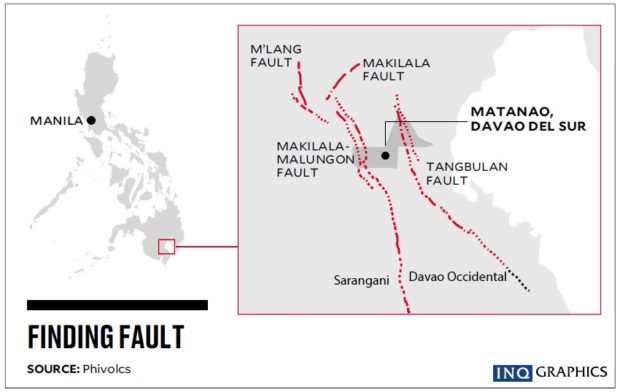
Now geologists are looking at the Tangbulan Fault as the possible generator of the 6.9-magnitude earthquake that shook Davao del Sur province and a large part of Mindanao on Sunday.
Science Undersecretary Renato Solidum, the officer in charge of the Philippine Institute of Volcanology and Seismology (Phivolcs), described the Tangbulan Fault as running parallel to the east of the Makilala-Malungon Fault, the longest fracture within the Cotabato fault system that includes the Mlang and the Makilala faults.
Full power
As it is similar in length to the Makilala-Malungon Fault, the Tangbulan Fault can also generate a 7.2-magnitude earthquake.
During the series of quakes that struck Cotabato province in October, geologists closely watched the Makilala-Malungon Fault because of its proximity to the two faults that had moved and because of its capacity to generate a 7.2-magnitude temblor.
The Mlang Fault generated a 6.3-magnitude quake on Oct. 16, which turned out to be the foreshock of the 6.6-magnitude quake of Oct. 29. The Makilala Fault movement on Oct. 31 unleashed a 6.5-magnitude quake.
The Makilala-Malungon Fault runs 65 kilometers from Makilala, Cotabato province, to Sarangani province, while the Tangbulan Fault stretches 62.2 km from Bansalan, Davao del Sur province, to Santa Maria, Davao Occidental province.
In a phone interview on Monday, Solidum said that after the 6.9-magnitude quake on Sunday, he would not discount the possibility of a much stronger earthquake occurring in Tangbulan, although the chances of a bigger quake to occur within this fault would be low after the release of that much energy.
“The faults are stressed, that’s why. It’s not surprising that they move,” he said.
Once energy has been released, a period of rest follows, he added.
Partial movement
Jeffrey Perez, supervising science research specialist at Phivolcs, expressed surprise that the fault had moved sooner than expected.
“We expected it to move but not this fast,” he said, but added that Phivolcs had been more prepared because geologists were already at the site the day after the earthquake.
The Tangbulan Fault, Perez said, runs somewhere near Bansalan town through Matanao, Hagonoy and Padada down to Sulop and Malalag in Davao del Sur, and Santa Maria in Davao Occidental.
Perez said that the lower magnitude of the quake—referring to the 6.9-magnitude against the maximum 7.2 magnitude—meant that only a portion of the fault had moved and Phivolcs had yet to find out which.
“Not the entire stretch had moved but we still had to find out which portion of the fault moved,” he told the Inquirer.
Perez, who flew in to Davao City on Monday, joined the Office of Civil Defense in an aerial survey of the quake-stricken sites to check the ground for ruptures and to survey the damage from the air.

