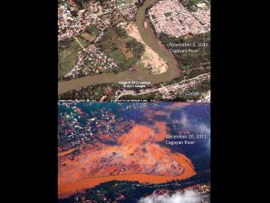
Like tsunami, floods + deadly debris

BEFORE AND AFTER VIEWS Satellite and aerial shots of a bend of the Cagayan de Oro River which suffered the brunt of the deadly flash flood triggered by “Sendong” early dawn of Dec. 17.
Like a rampaging tsunami, but with more destructive debris that tore up everything in its path.
This was how a University of the Philippines geologist described the flash floods that hit Iligan City at the height of Tropical Storm “Sendong” which left more than 400 dead in the city alone.
Alfredo Mahar Lagmay explained that the rushing waters which came from the upstream part of the Mandulog River were so strong that they swept away everything in their path—from rocks, mud, to whole trees.
“It was like a tsunami, but with more debris that made it even more erosive,” Lagmay said, as he described the extent of the “hyperconcentrated” flash flood’s strength.
And while illegal logging in the mountains above the city may have been a factor in the destruction, Lagmay said the primary cause of the flash floods was the heavy rains.
Article continues after this advertisement“Logging—may it be legal or illegal—may have aggravated the floods, but the primary reason for this was the extreme rainfall brought about by Sendong,” he told a press briefing yesterday.
Article continues after this advertisementUP sends a team
Lagmay, a professor at the National Institute of Geological Sciences, was part of a team that the university had sent to Iligan City after the flash floods which swept away entire homes and communities.
The storm dumped 350 millimeters of rain on northwestern Mindanao on the night of Dec. 16 up to the early hours of Dec. 17, causing the flash floods that crept in while people slept soundly in their homes.
This was less than the 455 mm of rainfall that Tropical Storm “Ondoy” dumped on Metro Manila in 2009, but just as severe, Lagmay noted.
As of Dec. 28, 456 were reported to have died and 466 still missing in Iligan City alone, with 863 injured, Lagmay said.
The UP team focused its efforts on Iligan City through a partnership with Sen. Koko Pimentel.
Worse than Guinsaugon
“We think the destruction in Iligan City is worse than that of Cagayan de Oro… even worse than what happened in 2006 in Guinsaugon (Southern Leyte),” Lagmay said.
Describing the flash floods which rampaged through Iligan City, the geologist said the floods were of a high velocity and highly erosive because of the debris that the waters took with them from the upstream Mandulog River.
According to the geologist, the flood plain—the area of flat land beside a river that is frequently flooded when a river becomes too full—is a natural part of the river system during events of extreme rainfall.
The Mandulog River runs for 50 kilometers, with the barangays of Santiago, Hinaplanon and Upper Hinaplanon in Iligan City far downstream.
These areas were among the worst hit by the floods, although Lagmay said the number of deaths may have been underreported because in some cases, entire communities were wiped out.
None left to report missing
“There was no one to report the missing because communities were wiped out,” he explained.
Lagmay described the flood coming from upstream as not just water but filled with rocks, sediments, logs and everything it encountered in its path—making it more destructive.
“It’s a little similar to lahar but not quite because lahar is volcanic in nature,” he said.
In some areas of the Mandulog River, the floods wiped out everything from 300 meters up to a kilometer away from the river bank.
“I even saw some areas on the riverbanks where trees were uprooted and fallen,” said UP vice president for public affairs Prospero de Vera.
Lagmay said the damage along the riverbank stretched for some 35 km.
Flattened subdivision
He also showed reporters a photo of Orchid Homes Subdivision in Santiago town, which used to be a village with concrete houses.
After Sendong’s wrath, the stone-and-concrete subdivision had been flattened into debris and mud.
Lagmay recalled tearing up while taking aerial shots of the damage in Iligan City.
“It was the first time that I tore up while taking photos of the damage. I was so moved,” he said.
The 22-person team was composed of four subteams—a medical mission team, a public health team, Lagmay’s team of geologists and a forensics team.
UP president Alfredo Pascual said this was part of the university’s mandate to provide services to the country as required in the new UP charter.
No man’s land
While the geological team has yet to finalize its recommendations, one thing is clear: Lagmay said the town of Santiago should not be occupied again.
“If the same thing were to happen 10 years from now, the damage will be much greater,” he warned.
The city government has proposed a resettlement area in Sta. Elena, which Lagmay said “appears to be all right.”
Lying south of Iligan City, Sta. Elena was left undamaged by the floods.
The geologist, however, stressed the need for communities and individuals to be informed of the existing geohazard maps so that they know now to react in case of such calamities.
“If they don’t know there’s a geohazard map, then [they should] ask for one from the barangay, the officials. This must be a cooperative effort of everybody, including individuals,” he added.
Missing persons list
Forensic expert Dr. Maria Corazon de Ungria called for a more comprehensive missing persons list to be able to identify both the dead and the living.
She recalled that during their stay in Iligan City, she encountered medical professionals and community workers who were ready to help from day one but were not fully utilized as first responders.
“The local government and the community must be empowered to address the situation since they are the ones who are there, not the National Bureau of Investigation profilers,” said De Ungria.