MANILA, Philippines — Typhoon Tisoy somewhat weakened as it heads towards the Batangas-Northern Oriental Mindoro area mid-morning Tuesday, the state weather bureau said.
In its 11 a.m. Severe Weather Bulletin, the Philippine Atmospheric, Geophysical and Astronomical Services Administration (Pagasa) said the typhoon made its second landfall in Marinduque at 8:30 a.m. Tisoy first hit land in Gubat, Sorsogon, on Monday night.
The eye of Tisoy was located 55 kilometers (km) east of Calapan City in Oriental Mindoro at 10 a.m., moving westward at 25 km per hour (kph), Pagasa noted.
Tisoy was packing maximum sustained winds of 150 kph near the center and gustiness of up to 205 kph, it added.

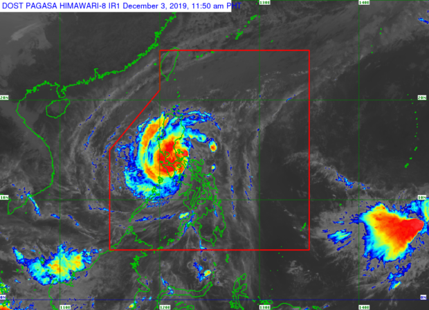
Satellite image from Pagasa
Between Tuesday morning and late afternoon, Pagasa said Romblon, Marinduque, Mindoro Provinces, Calabarzon, Bataan, Pampanga, Bulacan, and Metro Manila will experience frequent to continuous heavy to intense rains.
Meanwhile, occasional to frequent heavy rains will prevail over the Bicol region and the rest of Central Luzon as intermittent heavy rains will occur in Aklan, Antique, Capiz, and the northern portions of Negros Provinces, the weather bureau also said.
Between late afternoon Tuesday and Wednesday morning, Pagasa said Mindoro provinces, Central Luzon, Rizal, Northern Quezon including Polillo Islands, as well as Metro Manila will have frequent to continuous heavy (with isolated intense) rains.
In the same period, Pagasa said occasional heavy rains will be experienced in Cagayan Valley, Cordillera Administrative Region, Marinduque, Romblon and the rest of Calabarzon while intermittent heavy rains is predicted over the Calamian Islands.
The state weather bureau likewise warned that storm surges measuring up to three meters are likely over several coastal areas in Batangas, Marinduque, Mindoro Provinces, Romblon, Cavite, and Batangas.
The Tropical Cyclone Wind Signals (TCWS) raised over Ifugao, Mountain Province, Northern Cebu, Bohol, northern Negros Oriental, Eastern Samar, and the rest of Samar have already been lifted by Pagasa.
But TCWS Signal No. 3 is still hoisted over the following areas:
Luzon
- Burias Islands
- Romblon
- southern portion of Quezon (Perez
- Alabat
- Quezon
- Mauban
- Sampaloc
- Lucban
- Tayabas
- Pagbilao
- Lucena
- Sariaya
- Candelaria
- Dolores
- Tiaong
- San Antonio
- Atimonan
- Padre Burgos
- Agdangan
- Plaridel
- Unisan
- Pitogo
- Gumaca
- Lopez
- Macalelon
- General Luna
- Calauag
- Catanauan
- Guinayangan
- Tagkawayan
- Buenavista
- Mulanay
- San Narciso
- San Francisco
- San Andres)
- Marinduque
- Oriental Mindoro
- Occidental Mindoro including Lubang Island
- Batangas
- Cavite
- Laguna
The following, meanwhile, are placed under Signal No. 2, since these areas may expect winds of 61 kph to 120 kph within at least 24 hours:
Luzon
-
- Camarines Sur
- Camarines Norte
- Albay
- Catanduanes
- Sorsogon
- Metro Manila
- Bulacan
- Bataan
- Tarlac
- Pampanga
- Nueva Ecija
- southern Aurora (Dipaculao, Maria Aurora, Baler, San Luis, Dingalan)
- Rizal
- rest of Quezon including Polillo Islands
- Calamian Islands (Coron, Busuanga, Culion, Linapacan)
- Cuyo Islands (Cuyo, Magsaysay, Agutaya)
- Zambales
- Pangasinan
- Masbate, including Ticao Islands
Visayas
-
- Western portion of Northern Samar (Lavezares, Allen, Biri, Rosario, Victoria, San Jose, San Isidro, Bobon, Catarman, Lope de Vega)
- northwestern portion of Samar (Calbayog, Tagapul-am, Almagro, Sto. Niño) Aklan
- Capiz
- Northern Antique (Caluya, Libertad, Pandan, Sebaste, Culasi, Tibiao)
Also remaining under Signal No. 2 are:
Luzon
-
- Southern Isabela (Palanan)
- Dinapigue
- San Mariano
- San Guillermo
- Benito Soliven
- Naguilian
- Reina Mercedes
- Luna
- Aurora
- Cabana
- San Mateo
- Cauayan City
- Alicia
- Angadanan
- Ramon
- San Isidro
- Echague
- Cordon
- Santiago City
- Jones and San Agustin)
- Benguet
- Nueva Vizcaya
- Ilocos Sur
- La Union
- Quirino
- rest of Aurora
- and northern portion of Palawan (El Nido)
- Taytay
- Araceli
- Dumaran
Visayas
-
- Rest of Northern Samar
- rest of Samar
- Biliran
- northern Negros Occidental (Talisay)
- Calatrava
- Silay
- Enrique B. Magalona
- Victorias
- Manapla
- Cadiz
- Sagay
- Escalante
- Toboso
- Bacolod
- Murcia
- Salvador Benedicto
- San Carlos
- Bago
- Pulupandan
- Valladolid
- La Carlota
- San Enrique
- Pontevedra
- La Castellana
- Moises Padilla
- rest of Antique
- Iloilo
- Guimaras
- Leyte
Pagasa cautioned against sea travel, saying it remains risky especially for small sea vessels in the seaboards of areas placed under TCWS, seaboards of Northern Luzon, western seaboard of Palawan, seaboards of Visayas, and northern and eastern seaboards of Mindanao because of rough coastal conditions.
Pagasa further said gusty conditions may also prevail even in Northern Luzon areas that are not under any TCWS (especially in the coastal and mountainous zones) due to the northeast monsoon or amihan.
Pagasa advised the public, especially those residing in the said areas as well as in areas prone to floods and landslides, to take necessary precautionary actions, coordinate with local disaster risk reduction and management offices, and continue monitoring for weather updates.
Edited by KGA