Typhoon Tisoy maintains strength; Signal No. 3 up in 11 areas
https://www.facebook.com/PAGASA.DOST.GOV.PH/videos/522510005272033/
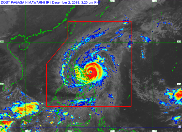
MANILA, Philippines — Tropical Cyclone Wind Signal (TCWS) No. 3 has been raised over 11 areas in the country as Typhoon Tisoy maintains its strength ahead of its expected landfall over Catanduanes, Albay, or Sorsogon, the Philippine Atmospheric, Geophysical and Astronomical Services Administration (Pagasa) reported Monday afternoon.
As of 1 p.m., Monday, Pagasa said Tisoy was spotted 140 kilometers east northeast of Catarman, Northern Samar and packing maximum sustained winds of 150 kilometers per hour (kph) and gustiness of up to 185 kph.
Tisoy is moving west at 20 kph.
Signal No. 3 is raised over Catanduanes, Camarines Sur, Albay, Sorsogon, southern portion of Camarines Norte, Masbate, Romblon, southern portion of Quezon, Northern Samar, northern portion of Easten Samar, and northern portion of Samar province.
Signal No. 2, meanwhile, is raised over Metro Manila, Bulacan, Bataan, Pampanga, Nueva Ecija, southern Aurora, Cavite, Batangas, Laguna, Rizal, the rest of Quezon including Polilio Islands, Oriental Mindoro, Occidental Mindoro, Marinduque, rest of Camarines Norte, Calamian Islands, southern portion of Zambales, rest of Eastern Samar, rest of Samar, Biliran, Aklan, Capiz, northern potion of Antique, northern portion of Negros Occidental, northern portion of Iloilo, Northern Cebu, and northern portion of Leyte.
Article continues after this advertisementSignal No. 1 is raised over Southern Isabela, Mountain Province, Ifugao, Benguet, Nueva Vizcaya, Ilocos Sur, La Union, Pangasinan, Quirino, rest of Aurora, rest of Zambales, rest of Antique, rest of Iloilo, Guimaras, rest of Negros Occidental, rest of Leyte, Southern Leyte, Dinagat Island, and Siargao Island.
Article continues after this advertisementPagasa said Tisoy is expected to cross Albay-Sorsogon area overnight and northern tip of Burias Island on Tuesday morning.
On Tuesday afternoon, it is expected to cross the Batangas-Mindoro area before reaching the West Philippine Sea in the evening.
Tisoy is expected to exit PAR on Thursday morning.
Between Monday afternoon and Tuesday afternoon, frequent to continuous heavy to intense rains are expected over Bicol Region, Northern Samar, Southern Quezon and Marinduque.
Occasional heavy rains are expected over Romblon, Mindoro provinces, Samar, eastern Samar and rest of Calabarzon.
Intermittent heavy rains over Metro Manila, Central Luzon, eastern portions of Cagayan and Isabela and rest of eastern Visayas.