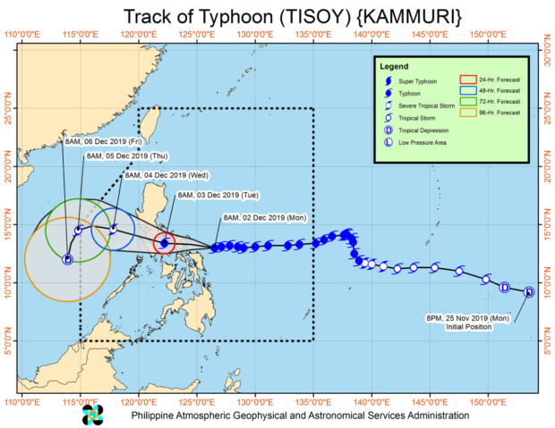
From Pagasa website
MANILA, Philippines — More areas were placed under Signal No. 3 ahead of Typhoon Tisoy’s (international name Kammuri) expected landfall.
As of 11 a.m., the typhoon maintained its strength while moving westward towards Bicol Peninsula, the Philippine Atmospheric, Geophysical and Astronomical Services Administration (Pagasa) said Monday.
Signal no. 3 was hoisted over the following since these areas were forecast to experience 121 to 170km/h winds in the next 18 hours:
Catanduanes, Camarines Sur, Albay, Sorsogon, the southern portion of Camarines Norte (Daet, San Vincente, San Lorenzon Ruiz, Basud, Mercedes), and Burias Islands
Signal No. 2 was declared in the following since these areas are likely to have 61 to 120 km/h winds in the next 24 hours:
Metro Manila, Bulacan, Bataan, Pampanga, eastern portion of Nueva Ecija ( Pantabangan, Rizal, General Mamerto Natividad, Cabanatuan, Santa Rosa, Jaen, San Antonio, Bongabon, Laur, Gabaldon, General Tinio, Palayan, San Leonardo, Cabiao, San Isidro, Gapan, Peñaranda) southern Aurora (Dipaculao, Maria Aurora, Baler, San Luis, Dingalan), Cavite, Batangas, Laguna, Rizal, Quezon including Polillo Islands, Oriental Mindoro, Occidental Mindoro, Marinduque, Romblon, rest of Camarines Norte, and Masbate including Ticao Island
And Signal No. 1 was raised in the following since these areas will experience 30 to 60 km/h winds in the next 36 hours:
Southern Isabela (Palanan, Dinapigue, San Mariano, San Guillermo, Benito Soliven, Naguilian, Reina Mercedes, Luna, Aurora, Cabatuan, San Mateo, Cauayan City, Alicia, Angadanan, Ramon, San Isidro, Echague, Cordon, Santiago City, Jones and San Agustin), Mountain Province, Ifugao, Benguet, Nueva Vizcaya, Ilocos Sur, La Union, Pangasinan, Quirino, rest of Aurora, rest of Nueva Ecija, Tarlac, Zambales, and Calamian Islands, Southern Isabela (Palanan, Dinapigue, San Mariano, San Guillermo, Benito Soliven, Naguilian, Reina Mercedes, Luna, Aurora, Cabatuan, San Mateo, Cauayan City, Alicia, Angadanan, Ramon, San Isidro, Echague, Cordon, Santiago City, Jones and San Agustin), Mountain Province, Ifugao, Benguet, Nueva Vizcaya, Ilocos Sur, La Union, Pangasinan, Quirino, rest of Aurora, rest of Nueva Ecija, Tarlac, Zambales, and Calamian Islands Aklan, Capiz, Antique, Iloilo, Guimaras, northern portion of Negros Occidental (Bacolod City, Bago City, Cadiz City, Calatrava, Enrique B. Magalona, Escalante City, La Carlota City, Manapla, Murcia, Pulupandan, Sagay City, Salvador Benedicto, San Carlos City, San Enrique, Silay City, Talisay City, Toboso, Valladolid, Victorias City), Northern Cebu (Bantayan, Madridejos, Santa Fe, Medellin, Bogo City, San Remigio, Tabogon, Tabuelan, Borbon, Sogod, Catmon, Asturias, and Camotes Islands), Metro Cebu (Balamban, Toledo City, Pinamungahan, Aloguinsan, Naga City, Talisay City, Cordova, Minglanilla, Lapu-Lapu City, Mandaue City, Cebu City, Consolacion, Liloan, Compostela, and Danao City), Leyte, and Southern Leyte, Dinagat Islands and Siargao Island
Tisoy was last spotted 235 kilometers east-southeast of Virac, Catanduanes or 250 kilometers east of Juban, Sorsogon. It was blowing winds of 150 km/h near the center and gusts of up to 185 km/h.
It continued to move west at 25 km/h, according to Pagasa’s 11 a.m. weather bulletin.
Pagasa said the typhoon is expected to make landfall over Catanduanes, Albay or Sorsogon between Monday night and early Tuesday.
Nonetheless, heavy rains are starting to be felt over the Bicol region, Samar provinces, and Biliran, Pagasa noted, while intermittent heavy rains are happening over Northern Cebu, Northern Negros Island, Dinagat Islands, Siargao Island, and the rest of Eastern Visayas.

