More areas in Bicol under Signal No. 3 as typhoon nears
MANILA, Philippines – More areas aside from Catanduanes in the Bicol region have been placed under Tropical Cyclone Wind Signal (TCWS) No. 3 as Typhoon Tisoy (international name: Kammuri) maintained its strength, the state weather bureau said.
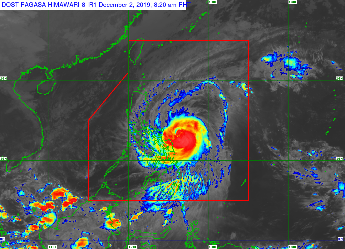
In its 8 a.m. weather update, the Philippine Atmospheric, Geophysical and Astronomical Services Administration (Pagasa) said it last spotted Tisoy 275 km east of Virac, Catanduanes.
It has a maximum sustained winds of 150 kilometers per hour (kph) near the center and gustiness of up to 185 kph.
Pagasa has placed the following areas under Signal No. 3:
- Catanduanes
- eastern portion of Camarines Sur (Caramoan, Presentacion, Garchitorena, Lagonoy, Tinambac, Siruma, San Jose, Goa ,Tigaon, Ocampo, Sagñay, Buhi, Iriga City ,Baao ,Nabua ,Bato)
- Albay
- northern part of Sorsogon (Donsol, Pilar, Castilla ,Sorsogon City, Prieto Diaz, Gubat, Casiguran, Barcelona, Juban and Magallanes)
Meanwhile, Signal No. 2 is up over the following areas
Article continues after this advertisement- Luzon
-
- Metro Manila
-
- Bulacan
-
- southern Aurora (Dingalan)
-
- Cavite
-
- Batangas
-
- Laguna
-
- Rizal
-
- Quezon including Polillo Islands
-
- Oriental Mindoro
-
- Occidental Mindoro
-
- Marinduque
-
- Romblon
-
- Camarines Norte
-
- rest of Camarines Sur
-
- Sorsogon
-
- Masbate (including Ticao and Burias Islands)
- Visayas
-
- Northern Samar
-
- Eastern Samar
-
- Samar
-
- Biliran
Signal No.1 is up over the following areas:
- Luzon
-
- southern Isabela (Palanan, Dinapigue, San Mariano, San Guillermo, Benito Soliven, Naguilian, Reina Mercedes, Luna, Aurora, Cabatuan, San Mateo, Cauayan City, Alicia, Angadanan, Ramon, San Isidro, Echague, Cordon, Santiago City, Jones and San Agustin)
-
- Mountain Province
-
- Ifugao
-
- Benguet
-
- Nueva Vizcaya
-
- Ilocos Sur
-
- La Union
-
- Pangasinan
-
- Quirino
-
- Aurora
-
- Nueva Ecija
-
- Tarlac
-
- Pampanga
-
- Zambales
-
- Bataan
-
- Calamian Islands
- Visayas
-
- Aklan
-
- Capiz
-
- Antique
-
- Iloilo
-
- Guimaras
-
- northern portion of Negros Occidental (Bacolod City, Bago City, Cadiz City, Calatrava, Enrique B. Magalona, Escalante City, La Carlota City, Manapla, Murcia, Pulupandan, Sagay City, Salvador Benedicto, San Carlos City, San Enrique, Silay City, Talisay City, Toboso, Valladolid, Victorias City)
-
- northern Cebu (Daanbantayan, Bantayan, Madridejos, Santa Fe, Medellin, Bogo City, San Remigio, Tabogon, Tabuelan, Borbon, Sogod, Catmon and Asturias)
-
- Metro Cebu (Balamban, Toledo City, Pinamungahan, Aloguinsan, Naga City, Talisay City, Cordova, Minglanilla, Lapu-Lapu City, Mandaue City, Cebu City, Consolacion, Liloan, Compostela
- and Danao City)
-
- Leyte
-
- Southern Leyte
- Mindanao
-
- Dinagat Islands and Siargao Island
The state weather bureau said occasional heavy rains are expected over the Bicol region, Samar provinces and Biliran while intermittent heavy rains may prevail over northern Cebu, Dinagat Islands, Siargao Island, and the rest of Eastern Visayas.
Pagasa has advised residents in the affected areas, especially those living in areas identified to be highly or very highly susceptible to flooding and rain-induced landslides, to carry out precautionary measures, coordinate with local disaster risk reduction and management offices, and continue monitoring weather updates.