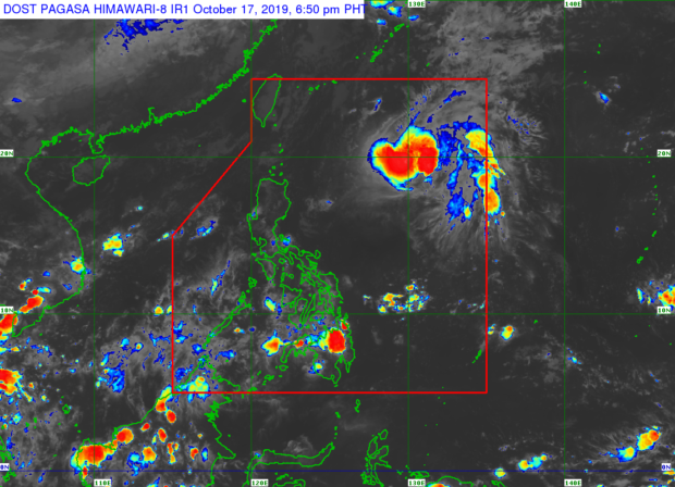
MANILA, Philippines – There is a huge chance that Tropical Depression ‘Perla’ may weaken and revert back to a low-pressure area (LPA) on Sunday, even as it slightly intensified since the state weather bureau’s update on Thursday noon.
The Philippine Atmospheric, Geophysical, Astronomical Services Administration (Pagasa) said that this possible scenario for Perla, which now packs maximum sustained winds of 55 kilometers per hour (kph) near the center and gustiness of up to 70 kilometers per hour, is because of prevailing cold winds in its path.
Perla was last located 840 kilometers east of Aparri in Cagayan and is moving north northwest at a speed of 15 kph — directly into the northeasterly surface windflow or Amihan.
“By Sunday, it is possible that by this time it has weakened to a low-pressure area because of the cold weather conditions in the extreme northern Luzon due to the prevailing northeasterly surface windflow,” Weather Specialist Ana Clauren said.
However, it is still possible for areas in the extreme Northern Luzon to experience rainshowers, which may also lead to the placing of tropical storm warning signals in the Batanes, Babuyan Group of Islands, and in Apayao.
Perla though does not have a direct effect on the rest of the country’s weather systems, as rainfall in Palawan, Visayas, and some parts of Mindanao are caused by clouds in the intertropical convergence zone (ITCZ).
For the next 24 hours, Cagayan and Batanes area will continue to experience cloudy skies with light rains and thunderstorms, while the rest of Luzon including Metro Manila will experience hot and humid weathers.
Cloudy skies with occasional rainshowers and thunderstorms are also expected over Palawan, Visayas, and the Zamboanga peninsula due to ITCZ. The rest of Mindanao meanwhile will have hot and humid days, but may also experience rains in the afternoon.
