MANILA, Philippines – The low pressure area (LPA) previously spotted east of Mindanao has moved outside the Philippine area of responsibility (PAR) and the weather bureau said it is not expected to develop into a storm.
Reports from the Philippine Atmospheric, Geophysical, and Astronomical Services Administration (Pagasa) on Thursday afternoon said the through of the LPA was last located 1,070 kilometers east of Eastern Visayas.
“Sa ating pagtaya mababa pa rin ang tsansa na ito’y maging bagyo in the next 48 hours, ito’y posibleng mag-stall or tumambay dito sa silangnang bahagi ng PAR, posible ring makabalik sa loob at posible rin pong malusaw eventually,” weather specialist Ariel Rojas said.
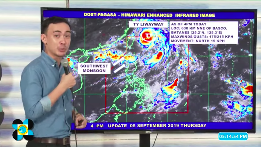
Meanwhile, Typhoon Liwayway (International name: Lingling) enhances the southwest monsoon or Habagat, even as it continues to move away from PAR. As of 4:00 p.m., Lingling’s eye was spotted 630 kilometers north northeast of Basco, Batanes.
It has maximum sustained winds of 175 kilometers per hour (kph) and gustiness of up to 215 kph. It is moving north at a speed of 15 kph.
“Patuloy pa ring hinihila ni Liwayway itong ating southwest monsoon o hanging Habagat, na nakaka-apekto sa Northern Luzon,” Rojas said.
Weather for the western and northern parts of Luzon is expected to be cloudy with scattered rains on Friday, while the remaining parts of Luzon, including Metro Manila, will experience generally fair weather.
Central and Eastern Visayas, including the different parts of Mindanao, will experience cloudy skies and rainshowers due to the trough of the LPA. A gale warning was also raised for the northern and western seaboards of Luzon, as waves can reach a height of 2.8 meters up to 4.5 meters.


