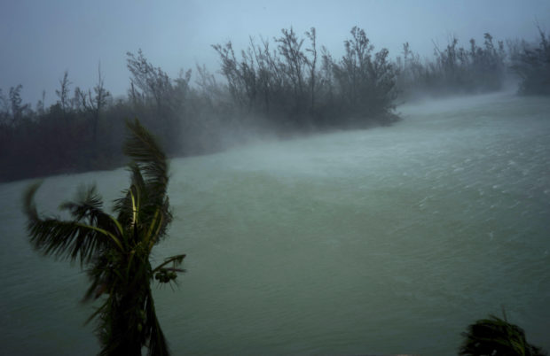
Strong winds from Hurricane Dorian blow the tops of trees and brush while whisking up water from the surface of a canal that leads to the sea, located behind the brush at top, seen from the balcony of a hotel in Freeport, Grand Bahama, Bahamas, Monday, Sept. 2, 2019. Hurricane Dorian hovered over the Bahamas on Monday, pummeling the islands with a fearsome Category 4 assault that forced even rescue crews to take shelter until the onslaught passes. (AP Photo/Ramon Espinosa)
FREEPORT, Bahamas — Hurricane Dorian came to a catastrophic daylong halt over the northwest Bahamas, killing at least five people and injuring 21 others while drowning islands and buildings, including the Grand Bahama airport.
“We are in the midst of a historic tragedy,” Prime Minister Hubert Minnis said. “The devastation is unprecedented and extensive.”
Winds and rain continued to pound Abaco and Grand Bahama islands, sending people fleeing the floodwaters from one shelter to another as walls of water lapped into the second floors of buildings, trapped people in attics, and inundated the airport under 6 feet of water.
The five people killed and 21 injured were airlifted to the capital by the U.S. Coast Guard, Bahamas officials said.
By Tuesday morning, the storm’s top sustained winds had dipped to 193 kph (120 mph), making it a Category 3 hurricane, but it remained almost stationary. It was centered 40 kilometers (25 miles) northeast of Freeport – roughly the same distance from the city as at 9 a.m. Monday. Hurricane-force winds extended out as far as 75 kilometers (45 mph) in some directions.
Hundreds of thousands of people in Florida, Georgia, and South Carolina were ordered to evacuate before the storm rolls up the Eastern Seaboard, bringing the possibility of life-threatening storm-surge flooding even if the storm’s heart stays offshore, as forecast. Several large airports announced closures and many flights were cancelled for Monday and Tuesday.
The U.S. Coast Guard airlifted at least 21 people injured on Abaco Island, which Dorian hit on Sunday with sustained winds of 295 kph (185 mph) and gusts up to 355 kph (220 mph), a strength matched only by the Labor Day hurricane of 1935, before storms were named. Scientists said climate change generally has been fueling more powerful and wetter storms and the only recorded storm more powerful than Dorian was Hurricane Allen in 1980, with 305 kph (190 mph) winds, though it did not make landfall at that strength.
Abaco and Grand Bahama, neither much more than 40 feet (12 meters) above sea level at their highest points, are home to some 70,000 people.
Bahamian officials said they received a “tremendous” number of calls from people in flooded homes. One radio station said it received more than 2,000 distress messages, including reports of a 5-month-old baby stranded on a roof and a woman with six grandchildren who cut a hole in a roof to escape rising floodwaters. At least two designated storm shelters flooded.
Dorian killed one person in Puerto Rico, at the start of its path through the Caribbean.
Minnis said many homes and buildings were severely damaged or destroyed, but it was too early to say how much the rebuilding effort would cost. Choppy brown floodwaters reached roofs and the top of palm trees on Monday.
Parliament member Iram Lewis told The Associated Press his greatest fear was that waters would keep rising overnight and that stranded people would lose contact with officials as cellphone batteries died.
“It is scary,” he said, adding that Grand Bahama’s airport was 6 feet (almost 2 meters) underwater and that people were moving shelters as floodwaters kept surging. “We’re definitely in dire straits.”
The U.S. National Hurricane Center said Dorian was expected to start moving slowly to the west-northwest Tuesday while continuing to pound Grand Bahama Island into the morning.
Strong winds move the palms of the palm trees at the first moment of the arrival of Hurricane Dorian in Freeport, Grand Bahama, Bahamas, Sunday, Sept. 1, 2019. (AP Photo/Ramon Espinosa)
The Center said the track would carry the storm “dangerously close to the Florida east coast late Tuesday through Wednesday evening and then move dangerously close to the Georgia and South Carolina coasts on Wednesday night and Thursday.”
While it was expected to stay offshore, meteorologist Daniel Brown cautioned that “only a small deviation” could draw the storm’s dangerous core toward land.
A mandatory evacuation of the entire South Carolina coast took effect Monday covering about 830,000 people, and transportation officials reversed all lanes of Interstate 26 from Charleston to head inland earlier than planned after noticing traffic jams from evacuees and vacationers heading home on Labor Day, Gov. Henry McMaster said.
A few hours later, Georgia Gov. Brian Kemp ordered mandatory evacuations for that state’s Atlantic coast, also starting at midday Monday.
Authorities in Florida also ordered some mandatory evacuations.
FlightAware.com reported that airlines had canceled 1,361 flights within, into or out of the US by Monday afternoon – vastly above an average day – with Fort Lauderdale International the most affected, and airlines had already canceled 1,057 flights for Tuesday, many involving Orlando, Fort Lauderdale and Miami airports.
A hurricane watch was in effect for Florida’s East Coast from Deerfield Beach north to South Santee River in South Carolina. A storm surge watch was extended northward to South Santee River in South Carolina. Lake Okeechobee was under a tropical storm watch.
A National Guard official, John Anderson, said many people were complying with the evacuation orders.
“We have not seen much resistance at all,” he said. /kga