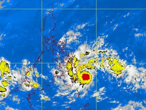
MANILA, Philippines—Tropical storm Sendong slightly intensified as it moved towards Davao Oriental, the Philippine Atmospheric Geophysical and Astronomical Services Administration said Friday.
In its latest bulletin, Sendong was last seen 180 kilometers east southeast of Hinatuan, Surigao del Sur with maximum winds of 75 kilometers per hour near the center and gustiness up to 90 kph.
Signal number 2 was hoisted over the following provinces: Southern Leyte, Bohol, Southern Cebu, Southern Negros, Siquijor Island, Surigao Del Norte, Siargao Island, Surigao Del Sur, Dinagat Province, Agusan Provinces, Davao del Norte, Davao Oriental, Samal Island, Lanao Provinces, Misamis Provinces, Zamboanga Provinces, North Cotabato, Compostela Valley, Bukidnon, Camiguin and Maguindanao.
Signal number 1 was declared in Palawan, Cuyo Island, Eastern Samar, Western Samar, Northern Leyte, Northern Cebu, Northern Negros, Iloilo, Capiz, Antique, Aklan , Guimaras Province, Davao Del Sur, Sultan Kudarat, South Cotabato, Sarangani Province and Basilan Province.
Estimated rainfall amount was from 10 to 25 mm per hour (heavy) within the 400-kilometer diameter of Sendong, Pagas added.
It was expected to make landfall early this afternoon over Davao Oriental by Friday afternoon;
100 kilometers southwest of Dipolog City Saturday morning; 190 kilometers west of Puerto Princesa City by Sunday morning; and expected to exit the Philippine area of responsibility by Sunday evening.
Originally posted: 9:27 am | Friday, December 16th, 2011
