Cebu slide unique, gov’t geologists say

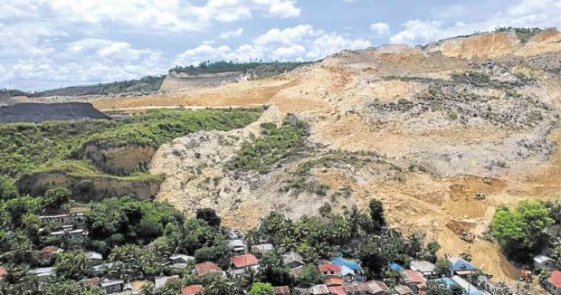
ALTERED LANDSCAPE The landslide that hit the village of Tinaan in Naga City, Cebu province, has altered the landscape of the mountainside community thriving near a quarry site. CHRISTIAN MANINGO / CEBU DAILY NEWS
NAGA CITY — Last month’s massive landslide in a mountain community in Naga City that killed more than 60 people did not just erode the soil but completely collapsed or sank it, according to a team of geologists from the Mines and Geosciences Bureau (MGB).
“It was a one-of-a-kind landslide. It was unique,” the MGB chief geologist, Liza Manzano, told reporters at the Naga City Hall on Monday.
Manzano said four factors contributed to the phenomenon: soil characteristic, previous earthquakes, climate and human activities.
Quarry operations
While the landslide was caused mainly by environmental factors, quarry operations in the mountain of Barangay Tinaan in Naga also contributed to the collapse, she said.
“Any activity that you do to change the landscape of the mountain, including quarry operations, is contributory to the incident,” she said.
A separate team from the MGB that conducted another inspection had ruled that Apo Land and Quarry Corp. (ALQC), which operates at Barangay Tinaan, did not commit any malpractice.
But Environment Secretary Roy Cimatu, who attended the presentation of the MGB in Naga, said he still would not lift the ban on the quarry activities of ALQC while the investigation continued.
“No lifting of ban [for now] because it is still dangerous for quarrying operations,” he said, without elaborating.
Quake impact
According to Manzano, the 7.2-magnitude earthquake that struck Bohol and Cebu provinces in 2013 “greatly affected the stability of the soil” in the mountain of Barangay Tinaan.
“The shift and ponding of subterranean flow may have caused the buildup of hydrostatic pressure that leads to the landslide,” she said, citing the MGB report.

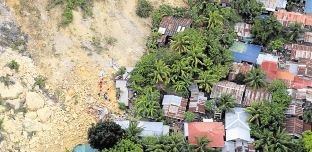
BURIED Soil and rocks bury a section of Barangay Tinaan in Naga City, killing more than 60 villagers. —PHOTO COURTESY OF OFFICE OF THE PRESIDENTIAL ASSISTANT FOR THE VISAYAS
Hydrostatic pressure is the force exerted by a fluid — water in this instance — due to gravity.
Zones
Manzano said the highly porous and water solubility characteristic of limestone, which largely composes soil in Naga City, also contributed to the slide.
The report also included a new delineation map, which determined three zones in the periphery of the landslide area: danger zone, no permanent habitation zone and regulated zone.
The danger zone, which includes the immediate surrounding of ground zero, is strictly off-limits to settlers.
The no permanent habitation zone, on the other hand, is outside the immediate danger zone. It can be converted into an eco park but cannot be used for urban settlements.
Regulated zones are located several meters from ground zero.
Manzano said further studies had to be made to find out whether residents in the area would be allowed to return home.
Geotagging will be conducted on Wednesday by personnel of the Department of Environment and Natural Resources and the Naga City government to determine the houses that need to be relocated.
Naga Mayor Kristine Vanessa Chiong said they would present the relocation plan to the affected families once they finished with the geotagging.
“I am ready. I already submitted the financial humanitarian assistance scheme and options once the final list of affected families will be available,” she said.