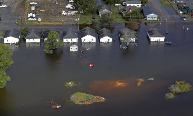
In this photo, taken on Monday, Sept. 17, 2018, floodwaters from Hurricane Florence surrounds homes in Dillon, South Carolina. Scientists say climate change likely boosted rainfall totals for both Florence and 2017’s Harvey. (Photo by GERALD HERBERT / AP)
GEORGETOWN, South Carolina — A week ago, firefighters in Conway went to a neighborhood and told surprised residents their houses would flood from Hurricane “Florence” even though they had never had water in them before.
On Monday and Tuesday, those same firefighters checked on those same neighborhoods with maps that detailed each of the nearly 1,000 homes that could expect to be inundated.
“It’s kind of playing out exactly like we forecast,” Conway Fire Chief Le Hendrick said.
Twelve days after the once-fierce hurricane arrived on the coast, and more than a week after it blew north and dissipated, rivers swollen by its relentless rains are still flooding homes and businesses in their paths as they make their way to the sea.
The slow-moving disaster has allowed forecasters to pinpoint exactly who will flood. There have been few rescues or surprises in South Carolina — just black, reeking water slowly seeping in and even more slowly receding.
“You find yourself sitting around a lot and thinking, ’What if,’ or, ’I wonder what things are like right now,’” said Vivian Chestnut, who left her home in Conway a week ago and might not get back until well into October. “And wondering what you are going to find when you finally get back.”
The Waccamaw River, which flows through the city of 23,000, was expected to crest on Wednesday at 21.7 feet (6.6 meters). It surpassed the previous record high of 17.9 feet (5.5 meters) set in 2016 by Hurricane Matthew on Friday.
The waterway was not expected to drop below 18 feet (5.5 meters) or so until sometime next week. The river floods at 11 feet (3.4 meters).
All that water is making its way to Georgetown, where five different rivers reach the sea. Officials there said the worst of the flooding would start Wednesday and last until Thursday, likely leaving only one highway into the city.
And if that weren’t bad enough, more weather was forming off the coast in a hurricane season that still has two months to go. National Hurricane Center forecasters watching a low pressure area about 200 miles (320 kilometers) south of Cape Hatteras, North Carolina, said it could become a tropical depression as it approaches the coast before moving quickly to the north.
While it will likely dump some additional rain on the Florence-battered city of Wilmington, it wasn’t expected to be significant enough to worsen the flooding.
“It shouldn’t put much of a dent in the rivers,” said Reid Hawkins, a National Weather Service meteorologist in Wilmington.
Officials at South Carolina’s state-owned utility were still warily monitoring two coal-ash ponds near Conway. Santee Cooper officials said floodwater from the Waccamaw River had already made it into one pond, but most of the ash had already been removed from it during an earlier cleanup project.
The river is likely to flood the second pond soon, but the utility promised it has taken steps to lessen the environmental impact, such as installing silt fencing and a floating environmental containment boom.
Not far from the ash ponds, engineers are keeping an eye on U.S. Highway 501, the main link to Myrtle Beach. Water is now touching a temporary barrier of sand and plastic that has been erected to keep water off the bridge. Called the Lifeline, the temporary wall will remain effective if the water doesn’t rise more than an additional 5 feet (1.5 meters) from its current level, according to the state Department of Transportation.
In North Carolina the rivers have stopped rising, but the recovery process is really just beginning. In rural Jones County, between Kinston and New Bern, two of the county’s six schools will have to be demolished after floodwaters left mold and mildew in their wake, School Superintendent Michael Bracy said. /atm