
Track of Typhoon “Paeng” (Map posted on the Pagasa Facebook page at 11:22 p.m. on Tuesday, Sept. 26, 2018.)
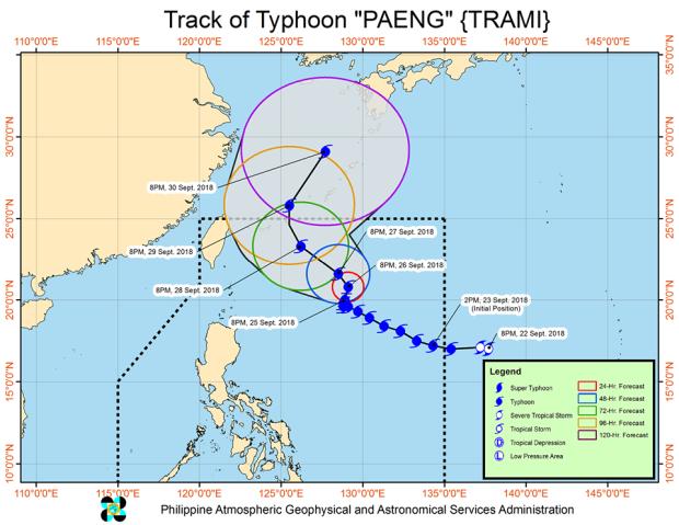
Typhoon “Paeng,” internationally known as “Trami,” slightly weakened on Tuesday and continued to move slowly toward the north-northeast, according to the Philippine Atmospheric, Geophysical and Astronomical Services Administration (Pagasa).
According to the bulletin issued by Pagasa at 11:00 p.m., the typhoon may bring light to moderate rains over Northern Luzon on Friday.
As of this writing, Pagasa had not issued any tropical cyclone warning signals. But sea travel remained risky over the northern and eastern seaboards of Luzon and the eastern seaboard of Visayas.
Paeng is expected to exit the Philippine area of responsibility (PAR) on Saturday.
Meanwhile, as of 10:00 p.m. on Tuesday, Pagasa located the eye of the typhoon at 725 km east of Basco, Batanes.
It had maximum sustained winds near the center of 190 kph, with a gustiness reaching up to 235 kph.
Pagasa forecast the following positions for the typhoon:
- Wednesday evening: 745 km east of Basco, Batanes
- Thursday evening: 690 km east-northeast of Basco, Batanes
- Friday evening: 540 km northeast of Basco, Batanes
- Saturday evening: 695 km north-northeast of Basco, Batanes (outside PAR)
- Sunday evening:1,125 km north-northeast of Basco, Batanes (outside PAR)
/atm