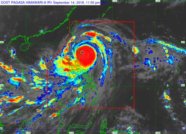
Typhoon “Ompong” (international name: Mangkhut) retained its ferocious strength and slightly shifted toward the provinces of Cagayan and Isabela on Friday as it barreled closer to land and widened its possible destructive effect to more areas and people in Luzon and the country’s eastern seaboard.
The Philippine Atmospheric, Geophysical and Astronomical Services Administration (Pagasa) expected the strongest typhoon to hit the country since Supertyphoon “Yolanda” (international name: Haiyan) to make landfall in the wee hours of Saturday.
But Ompong is not likely to intensify into a supertyphoon, according to weathermen, citing its unchanged sustained winds of 205 kilometers per hour and gusts of up to 255 kph as of 6 p.m. on Friday.
Landslides feared
More than 5.2 million people are at risk from the storm, which the Hawaii-based Joint Typhoon Warning Center categorizes as a supertyphoon with powerful winds and gusts equivalent to a Category 5 Atlantic hurricane.
A huge rain cloud band 900 km wide, combined with the prevailing southwest monsoon rains, could set off landslides and flash floods, Pagasa warned.
With the storm moving northwest at 30 kph, senior weather specialist Chris Perez expected Ompong to make landfall between 1 a.m. and 3 a.m. on Saturday.
As of 8 p.m. on Friday, the eye of the storm had grown bigger, an indication that it had already reached its peak and was starting to weaken, Pagasa forecaster Rene Paciente said.
The typhoon had a 125-km-wide eye, Pagasa said on Thursday.
In a press briefing late on Friday night, Paciente said it was possible Ompong could weaken before making landfall, though he warned that it would still be packing powerful winds.
As of 7 p.m., storm Signal No. 4 had been raised over Cagayan, northern Isabela, Apayao and Abra; storm Signal no. 3 in Batanes, Babuyan group of islands, southern Isabela, Ilocos Norte, Ilocos Sur, La Union, Kalinga, Mountain Province, Benguet, Ifugao, Nueva Vizcaya, Quirino and Northern Aurora; storm Signal No. 2 over Pangasinan, Tarlac, Nueva Ecija, southern Aurora, Zambales, Pampanga, Bulacan, Northern Quezon including Polillo Island; and storm Signal No. 1 over Bataan, Rizal, Metro Manila, Cavite, Batangas, Laguna, rest of Quezon, northern Occidental Mindoro including Lubang Island, northern Oriental Mindoro, Masbate, Marinduque, Camarines Norte, Camarines Sur, Catanduanes, Albay, Sorsogon, and Burias and Ticao Islands.
Volatile seas
Volatile seas are expected in areas under storm signals 2 to 4, with coastal towns in Cagayan and Isabela likely to experience storm surges as high as 6 meters, the weather bureau said.
“The shallower the coasts, the stronger the storm surges will be generated,” Perez said.
The National Disaster Risk Reduction and Management Council (NDRRMC) said that of the estimated 5.2 million people in the typhoon’s path, “nearly a million under the poverty line” in Northern Luzon could go hungry in the next few days.
In a press briefing, NDRRMC spokesperson Edgar Posadas said the estimates were given as a snapshot of the worst-case aftermath of the typhoon.
“These are people who, once they are hit by the storm, will be the most affected because they don’t have much coping mechanisms, they have little resources and capabilities,” Posadas said.
A total of 55,700 houses made of light materials in 2,091 barangays across Northern Luzon are expected to suffer Ompong’s brunt.
Pagasa said Ompong was tracked as of 7 p.m. on Friday about 260 km east-northeast of Casiguran, Aurora province.
The storm is expected to exit the Philippine area of responsibility on Saturday night, Pagasa said. —With a report from AP
