
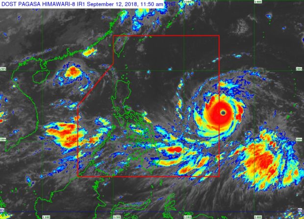
This satellite photo released by the Pagasa before midday Wednesday, Sept. 12, 2018, shows the eye of Typhoon ‘Mangkhut’ (right, center) coming close to the western border of the PAR. The strong typhoon is expected to enter the PAR at about 2 p.m. Wednesday. PAGASA PHOTO
Powerful typhoon “Mangkhut” grew even stronger midday Wednesday hours before its expected entry into the Philippine area of responsibility (PAR).
Mangkhut, which will be locally named “Ompong,” will enter the PAR at about 2 p.m., the Philippine Atmospheric, Geophysical and Astronomical Services Administration (Pagasa) said.
During its 11 a.m. briefing, Pagasa said the typhoon already had maximum sustained winds of 205 kilometers per hour with gusts of up to 255 kph. It was stronger by 5 kph from the previous sustained winds of 200 kph recorded earlier Wednesday morning.
Moving at a speed of 20 kph westward, it was spotted 1,190 kilometers east northeast of Guiuan, Eastern Samar.
Storm signals may be raised over Eastern Luzon on Thursday morning, Pagasa said.
Very strong winds, storm surges along coastal areas and heavy to intense rain is expected in Cagayan and Isabela by Friday and all over northern Luzon by Saturday as Mangkhut approached the Cagayan-Batanes area.
Heavy rain and strong winds are forecast over northern Luzon and parts of Central and Southern Luzon in the coming days.
Monsoon rain enhanced by Mangkhut is expected over Palawan, the Mindoro provinces and Western Visayas by Friday and Saturday.
Metro Manila and the rest of Luzon may experience light to moderate rain with occasional heavy rain and gusty winds starting Friday, Pagasa said. /cbb