Hazard map indicates higher quake risks in northern Japan
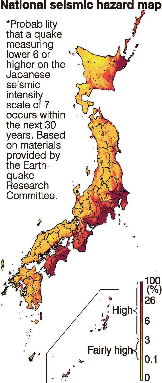
TOKYO — The probability of a major earthquake occurring within the next 30 years has increased significantly in eastern Hokkaido, including Kushiro and Nemuro, according to a new seismic hazard map released by a government committee.
The 2018 national seismic hazard map indicates the danger of an earthquake measuring at least lower 6 on the Japanese seismic intensity scale of 7. A review of the scale and probability of a quake occurring in the Chishima Trench on the Pacific side of Hokkaido led to the indication of a higher danger level for eastern Hokkaido.
The government’s Earthquake Research Committee on Tuesday released the map, which is based on data as of Jan. 1 this year. The seismic probability for Osaka, which was hit by a quake measuring a maximum of lower 6 on June 18, remained unchanged from the previous map released in April last year.
The hazard map was created based on the history of earthquakes that have occurred on plate boundaries, such as the Nankai Trough on the Pacific side, as well as on major active fault zones and within plates. A quake measuring lower 6 is viewed as a yardstick for destroying structures such as wooden houses with low quake resistance and concrete block walls.
The probability for Kushiro in eastern Hokkaido rose 22 percentage points from the previous map to 69 percent, while Nemuro saw its figure rise 15 points to 78 percent. The increases are attributed to the scale and probability of an earthquake occurring in the Chishima Trench, which were revised last year.
Article continues after this advertisementBy prefectural capitals, Chiba topped the list with 85 percent as concerns have grown about a quake directly hitting the Tokyo metropolitan area. It was followed by Yokohama with 82 percent and Mito with 81 percent.
Article continues after this advertisementThe probability for Tokyo was 48 percent, as the ground in areas near the Tokyo metropolitan government building is relatively firm. Coastal areas saw seismic probabilities exceeding 80 percent.
Among focal areas along the Nankai Trough, the probability for Kochi rose one point from the previous map to 75 percent. Shizuoka also rose one point to 70 percent.
Osaka, which was struck by a magnitude-6.1 quake registering a maximum of lower 6 on June 18, saw its probability remain the same as the previous map at 56 percent.
Probabilities were estimated on the assumption that a magnitude-6-level quake could occur anywhere. The Earthquake Research Committee said Osaka is likely to continue facing a high probability.