


Aghon heading to Sariaya, Quezon; signal # 2 up in 4 Luzon provinces
MANILA, Philippines — Tropical storm Aghon slightly intensified as it moved northwestward towards Sariaya, Quezon on Sunday morning, according to the state weather service.
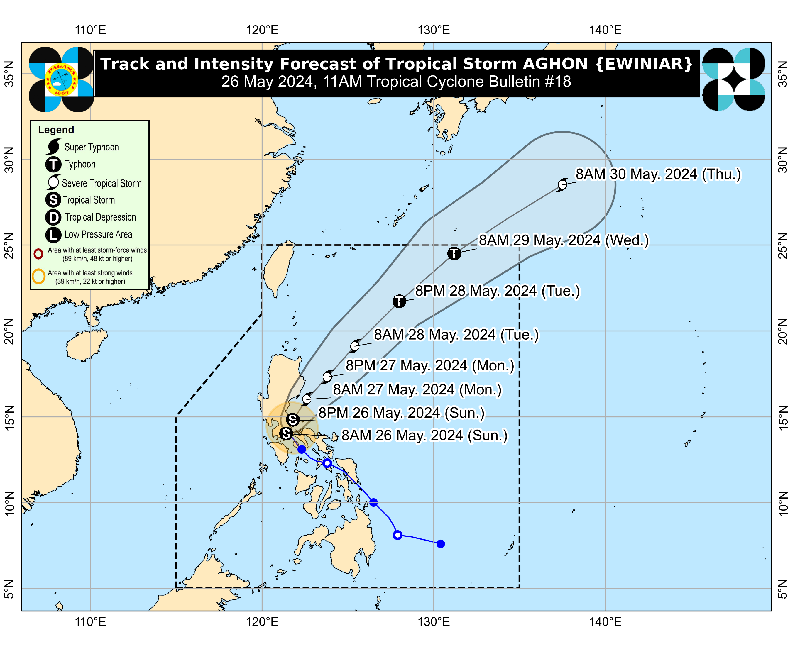
Based on its 11 a.m. cyclone bulletin, Philippine Atmospheric, Geophysical and Astronomical Services Administration (Pagasa) said Aghon is nearing the area packing maximum sustained winds of 75 kilometers per hour (kph) with gustiness of up to 125 kph.
Its movement returned to 10 kph and has been affecting areas and provinces in Luzon.
Pagasa said a Tropical Cyclone Wind Signal (TCWS) Number 2 is still raised in the following areas:
The northern and central portions of Quezon (Alabat, Perez, Quezon, Gumaca, Lopez, Macalelon, General Luna, Unisan, Pitogo, Plaridel, Agdangan, Padre Burgos, Atimonan, Mauban, Real, General Nakar, Infanta, Sampaloc, Pagbilao, Calauag, Lucban, City of Tayabas, Lucena City, Tiaong, Candelaria, Sariaya, Dolores, San Antonio)
Polillo Islands
Laguna
The eastern portion of Batangas (City of Tanauan, San Jose, Lipa City, Mataasnakahoy, Balete, Malvar, Santo Tomas, Cuenca, San Pascual, Batangas City, Ibaan, Padre Garcia, Rosario, San Juan, Taysan, Lobo) and the eastern portion of Rizal (Jala-Jala, Pililla, Tanay, Cardona, Binangonan, Morong, Baras)
TCWS Number 1 is also up in the following areas:
The southeastern portion of Isabela (Palanan, Dinapigue)
The southern portion of Quirino (Maddela, Nagtipunan)
The southern portion of Nueva Vizcaya (Alfonso Castaneda, Dupax del Sur, Dupax del Norte)
The eastern and southern portions of Nueva Ecija (General Tinio, Gabaldon, Bongabon, Pantabangan, Rizal, General Mamerto Natividad, Laur, Palayan City, Peñaranda, San Leonardo, City of Gapan, Cabanatuan City, Santa Rosa, San Isidro, Cabiao, San Antonio, Jaen, Zaragoza, Aliaga, Talavera, Llanera)
The southern portion of Bataan (Orani, Samal, City of Balanga, Abucay, Pilar, Orion, Limay, Mariveles, Bagac)
Aurora
The eastern portion of Pampanga (Candaba, San Luis, San Simon, Apalit, Santa Ana, Arayat, Mexico, Santa Rita, Guagua, Sasmuan, Macabebe, Masantol, Santo Tomas, Minalin, City of San Fernando, Bacolor, Lubao)
Bulacan
Metro Manila
The rest of Quezon
The rest of Rizal
Cavite
The rest of Batangas
The northern and central portions of Oriental Mindoro (Pinamalayan, Pola, Naujan, Victoria, Socorro, City of Calapan, Bansud, Gloria, Baco, San Teodoro, Puerto Galera, Bongabong)
Marinduque
The extreme northern portion of Romblon (Concepcion, Corcuera, Banton)
Camarines Norte
Camarines Sur
Due to Aghon’s strong winds, a gale warning was also hoisted over the coastal waters Aurora, Quezon and Marinduque, and the southern coastal waters of Batangas, and the northern coastal waters of Camarines Norte.
“Sea travel is risky for small seacrafts, including all motorbancas of any type of tonnage,” Pagasa warned.
“Outside the gale warning areas, Aghon will bring moderate to rough seas (1.5 to 3.5 meters) over the coastal waters along the northern and eastern seaboards of Luzon and the seaboard of Bicol Region,” it added.
For the next few hours, the tropical storm is expected to cross the east coast of Quezon or Aurora tonight or Monday morning.
“From Monday through the remainder of the forecast period, Aghon will gradually accelerate northeastward while intensifying. It is forecast to reach severe tropical storm category,” the state weather bureau said.
“Aghon is forecast to reach Typhoon category by Tuesday afternoon or evening and may exit the PAR (Philippine area of Responsibility) region on Wednesday,” it added.


