Chedeng picks up strength as it nears land; storm warnings up

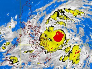
PAGASA-DOST MTSAT-EIR Satellite Image for 9 a.m., 25 May 2011. Graphics from https://www.pagasa.dost.gov.ph
MANILA, Philippines—(UPDATE) Tropical Storm Chedeng continued to bear down on the Philippines with greater force Tuesday, compelling the weather bureau to issue warnings in seven provinces in the Bicol and Eastern Visayas regions that were already beginning to feel the effects of the country’s third cyclone this year.
As of 10 a.m. Tuesday, the Philippine Atmospheric, Geophysical, and Astronomical Services Administration (Pagasa) said, Chedeng was located 490 kilometers east of Borongan, Eastern Samar, with maximum sustained winds of 105 kilometers per hour near the center and gusting up to 135 kph.
The storm had decelerated, however, and was moving west northwest at 13 kph, slower than its 15 kph speed on Monday.
Weather forecaster Robert Sawi said Chedeng was expected to intensify into a typhoon within the next 24 hours with center winds of at least 117 kph.
If it stays on its present course, Chedeng is expected to make landfall in the Cagayan-Isabela area on Friday afternoon.
Article continues after this advertisementSawi said the storm’s path could still change, however. A high-pressure area could block the disturbance from heading farther north and push it to move west to the Bicol provinces, he said.
Article continues after this advertisementThe effects of the storm started to be felt in the Bicol and Eastern Visayas on Tuesday, with Pagasa raising storm signal No. 1 over Catanduanes, Camarines Sur, Albay, Sorsogon and the three Samar provinces.
Starting Thursday, Sawi said, heavy rains would prevail in the provinces of Isabela, Quezon, and Aurora.
As the storm tracks northwest, stormy weather would be experienced in Central and Northern Luzon on Friday and Saturday, the Pagasa official said.
“It is unsafe to travel by land, air on sea during these days,” Sawi said.
Pagasa officials said Northern Luzon should brace itself for plenty of rain.
Flaviana Hilario, Pagasa acting deputy administrator for research and development, said the storm could produce over 400 mm of rainfall in 24 hours over Northern Luzon, which is close to the 455 mm rainfall brought by tropical storm Ondoy on September 26, 2009.
The rest of Luzon and the western parts of Visayas and Mindanao would also be under clouds and rains, Pagasa said.
Although these areas are not in the path of Chedeng, Pagasa said the southwest monsoon—which was being enhanced by the storm—would be the prevailing weather condition in these areas beginning Tuesday until Wednesday.
Metro Manila was likely to be sprared by Chedeng, although it would not be able to escape moderate and heavy rains later this week. Sawi said moderate to heavy rains from the southwest monsoon could dump 4.17 millimeters per hour of rainfall in Metro Manila, which could cause severe flooding.
Chedeng was forecast to be 390 km east southeast of Virac, Catanduanes or 180 km northeast Virac Wednesday morning.
By Thursday morning it will be 360 km southeast of Casiguran, Aurora and at 130 km northeast of Casiguran or 220 km southeast of Aparri, Cagayan by Friday morning. The storm is expected to exit the country via Batanes province.
President Aquino, meanwhile, is “closely monitoring” government preparations for the passage of Tropical Storm Chedeng, according to Malacanang spokesman Edwin Lacierda.
“(The President) has instructed the concerned agencies to do all that is possible to minimize loss of life and damage to property that may be brought about by the storm,” Lacierda said in a statement.
“We appeal to those in low-lying and landslide-prone areas to cooperate with local authorities if and when they are asked to evacuate. This is for your own safety,” Lacierda said.
Lacierda said that according to the National Disaster Risk and Reduction Management Council, flood-prone areas have been identified and local governments notified to take the necessary precautions, including the possible evacuation of low-lying and landslide prone areas.
The Department of Social Welfare and Development, on the other hand, has prepositioned goods in the areas where Chedeng may pass.
The Philippine National Police and the Philippine Coast Guard have been deployed to prevent ships and small fishermen from going out to sea at the critical hour.
“As has been the practice of this administration, forewarned is forearmed is the underlying strategy of our disaster response,” Lacierda said. “We are keeping the public updated so it can take the necessary precautions to minimize damage to property and life.”
Philippine National Police spokesman Chief Superintendent Agrimero Cruz Jr. said that their units covering areas that may be affected by Chedeng have been instructed by PNP chief Director General Raul Bacalzo to activate their Disaster Incident Management Task Groups (DIMTG) in coordination with civil defense authorities and local Disaster Risk Reduction Management Committee (DRRMC).
Cruz explained that regional police have also been told by Director Rommel Heredia, PNP Director for Police Community Relations and concurrent chairman of the PNP Sub-Committee on Disaster Management to deploy and pre-position Search and Rescue (SAR) units for disaster response in Leyte Samar, Sorsogon, Albay, Catanduanes, Camarines provinces, Quezon, Aurora, Isabela, Cagayan, and along the eastern shorelines on Luzon and the Visayas down to eastern Mindanao–areas which may be affected by the storm.
Among Heredia’s orders were for community leaders to be informed about disaster preparations and proactive actions in ensuring the safety of their communities, said Cruz.
The spokesman said that police will also assist in evacuating residents from affected areas. He added that they were also prepared to assist local government units and civil defense authorities in evacuation areas.
Cruz said that they will also be in close coordination with the DPWH and local government units in road-clearing operations. Police were also tasked to help in medical and relief operations.