


Metro Manila on typhoon’s path
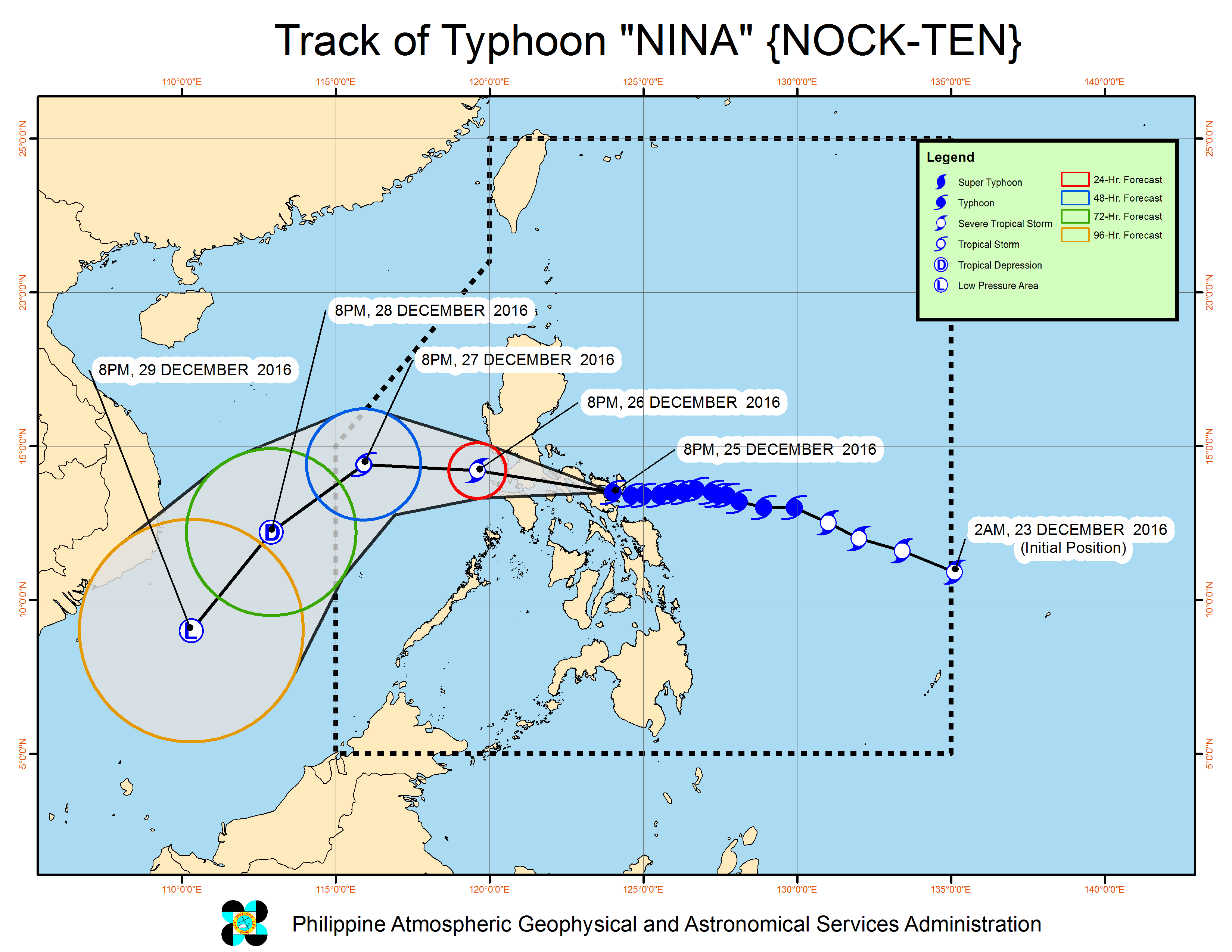
Typhoon “Nina” (international name: Nock-ten) made landfall over Bato town in Catanduanes at 6:30 p.m. on Sunday, according to the weather bureau, with 185 kilometer per hour maximum sustained winds near the center and gusts of up to 255 kph.
At the same time, it was moving slowly at 15 kph while headed westward toward southern and central Luzon, including Metro Manila, increasing the potential destruction from its passage.
The weather bureau Pagasa has raised storm warning signals over 40 areas within the typhoon’s path until its expected exit from the Luzon landmass through Zambales on Tuesday morning.
“The center is close to Catanduanes but the typhoon is over the whole of Bicol and parts of Northern Samar,” Pagasa forecaster Benison Estareja said in a news briefing at 5 p.m. on Sunday.
While the typhoon is expected to gradually weaken after landfall, it will remain strong while crossing Catanduanes, Camarines Sur, Camarines Norte, southern Quezon, Laguna, Batangas, Cavite then Metro Manila.
The Bicol provinces will experience stormy weather throughout the night. Metro Manila, Calabarzon, parts of Central Luzon, Marinduque and Mindoro will have stormy weather beginning on Monday morning.
According to Pagasa weather division chief Rene Paciente, Metro Manila will feel the brunt of the typhoon from 2 p.m. to 4 p.m. on Monday.
Pagasa raised the second highest warning, signal number 4, over Catanduanes and Camarines Sur.
Burias Islands, Albay, Camarines Norte, southern Quezon, Sorsogon and Marinduque were placed under signal number 3.
Metro Manila was placed under signal number 2 along with Masbate (including Ticao Island), Oriental Mindoro, Batangas, Laguna, Quezon (including Polillo island), Occidental Mindoro (including Lubang island), Romblon, Cavite, Rizal, Bulacan, Bataan and Northern Samar.
Signal number 1 was raised over Pangasinan, Nueva Ecija, Aurora, Quirino, Nueva Vizcaya, Zambales, Pampanga, Tarlac and the Calamian group of islands, Aklan, Capiz, Samar, Eastern Samar, Biliran, Leyte and Bantayan Island.
Aside from churning powerful winds, Pagasa warned the typhoon will bring moderate to heavy rains within its 500-kilometer diameter and whip ocean waves (storm surge) of up to 2.5 meters high over the coasts of Camarines Sur, Camarines Norte, Albay, Sorsogon and Catanduanes.
Nina is expected to be out of the Philippine area of responsibility by Wednesday.
While the only cyclone to hit the country this year, Nina’s onslaught came while many areas in Luzon are still recovering from four monster typhoons that struck in recent months.
Supertyphoon “Lawin” (Haima) devastated northern Luzon in the heels of Typhoon “Karen” (Sarika) over central and northern Luzon in October. Typhoon “Helen” (Megi) and Typhoon “Ferdie” (Meranti) struck extreme northern Luzon in September.
RELATED VIDEO


