


Typhoon ‘Nina’ barrels toward Bicol; storm signals up in 38 areas

Stranded passengers from Tabaco port are evacuated by the local government in Tabaco City, Albay province on December 24, 2016 after their seafaring vessels were prohibited from sailing ahead of typhoon Nock-Ten’s expected arrival.AFP
Typhoon “Nina” (international name Nock-Ten) maintained its powerful strength as it headed towards Bicol region on Sunday morning, Christmas Day.
Catanduanes, Albay and Camarines Sur were placed under Signal No. 3, the Philippine Atmospheric, Geophysical and Astronomical Services Administration (Pagasa) said.
Signal No. 2 was raised over southern Quezon, Marinduque, Camarines Norte, Masbate including Ticao and Burias Island, and Sorsogon and northern Samar.
Areas under Signal No. 1 were Metro Manila, Bataan, Nueva Ecija, southern Nueva Vizcaya, southern Quirino, Zambales, Pampanga, Tarlac, Bulacan, Cavite, Laguna, Batangas, Rizal, the rest of Quezon including Polillo Island, Aurora, Romblon, Occidental Mindoro including Lubang Island and Oriental Mindoro, Aklan, Capiz, Samar, Eastern Samar, Biliran, Leyte and Bantayan Island.
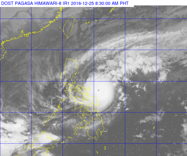
This satellite image from Pagasa shows the location of Typhoon Nina (Nock-Ten) as of 8:30 a.m. Monday.
READ: Christmas Day exodus
The typhoon is projected by forecasters to make landfall over Catanduanes on Sunday afternoon or evening. As of 4 a.m., it was located 250 kilometers east of Virac, Catanduanes.
Nina packed maximum sustained winds of 175 kilometers per hour near the center and gusts of up to 215 kph, moving at 15 kph westward.
Sea travel remained risky over the seaboards of Luzon, Samar and Leyte, Pagasa warned.
Moderate to heavy rains are expected within the 500-kilometer diameter of Nina. IDL


