‘Nepartak’ develops into typhoon before entering PAR
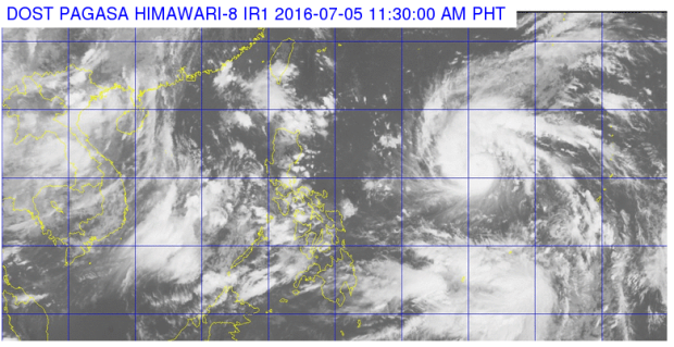
Tropical cyclone “Nepartak” intensified into a typhoon midday Tuesday, hours before it is poised to enter the Philippine area of responsibility (PAR).
In an update at 11 a.m., the Philippine Atmospheric, Geophysical and Astronomical Services Administration said that Nepartak packed maximum sustained winds of 120 kilometers per hour near the center and gusts of up to 150 kph.
READ: ‘Nepartak’ intensifies, to enhance southwest monsoon in PH
Nepartak, which will take its local name “Butchoy” when it enters PAR on Tuesday afternoon, was last tracked 1,570 kilometers east of Baler in Aurora. It has a speed of 30 kph northwest. It is expected to be 1,010 kilometers east of Aparri, Cagayan by tomorrow morning.
Pagasa earlier said that Nepartak won’t make landfall but it will enhance the southwest monsoon in the western portion of the country until the weekend Pagasa advises the public to remain alert for the next weather bulletin, and disaster risk reduction officials to “take appropriate actions.”
Moderate to heavy rains are forecast within the 300 kilometer diameter of Nepartak.
Late Monday afternoon, disaster officials maintained “Butchoy” is not expected to make landfall, and advised preparations for monsoon rains. It is expected to exit PAR on Saturday.
In an interview with Inquirer after a pre-disaster risk assessment meeting, with Pagasa in attendance, National Disaster Risk Reduction and Management Council (NDRRMC) spokesperson Mina Marasigan said “What will affect us is the ‘habagat,’ the southwest monsoon will bring the rains we will bring today and in the coming days up to the weekend.”
Marasigan also said the low pressure area detected over the weekend in the eastern section of the country had already dissipated.
Marasigan said the NDRRMC has issued a warning to its local counterparts. “Don’t be complacent just because you are only experiencing sporadic rainfall.”
Monday was the first pre-disaster risk assessment of new National Disaster Risk Reduction and Management Council executive director Ricardo Jalad. IDL


