


After ‘Lando,’ Pampanga, Bulacan fight floods
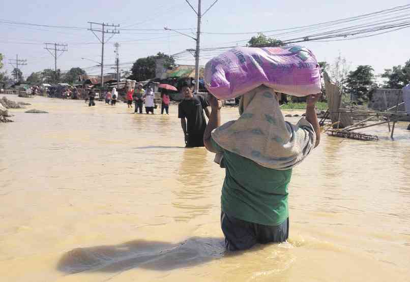
RESIDENTS of Calumpit, Bulacan, wade through floods after Typhoon “Lando” dumped heavy rain in Central Luzon last week. CARMELA REYES-ESTROPE
WITHOUT rain for days, much of Central Luzon has turned dry land more than a week after Typhoon “Lando” (international name: Koppu) made landfall in Casiguran town in Aurora province on Oct. 18.
In the coastal towns of Pampanga and Bulacan, however, people still battle with floods as water from 30 or so major rivers in Central Luzon—starting from Pantabangan River in Nueva Ecija province to the waterways along the 260-kilometer meandering route—drains downstream of the Pampanga River before emptying into Manila Bay.
On Monday, Simplicio Pangilinan, his wife and a dozen or so of their relatives continued to take refuge in his son’s second floor as neck-deep water (1.2 to 1.5 meters) showed no sign of subsiding in their village of Candelaria in Macabebe, Pampanga.
People in Candelaria have no dike to run to for safety whenever the Pampanga River overflows. Far down are six communities of Masantol town or what survived of these when the government widened the mouth of the river from 75 m to 750 m in 1998. Farther south are the Hagonoy and Calumpit towns of Bulacan.
Geologists and engineers refer to this area as the Pampanga Delta or downstream of the Pampanga River.
“It’s been almost a week now,” Pangilinan, a councilman, said of the flood. Thirty families in his neighborhood evacuated to the second floor of San Francisco Elementary School in Candelaria. They buy food in nearby Calumpit by banca.
“They don’t want to go to the other side of the river [to get to Macabebe town proper]. They’re afraid [because] water is high and the current is strong,” said Pangilinan, 53, an owner of a small fishpond.
But as floodwaters rise and linger—citing the successive Typhoons “Pedring” and “Quiel” in 2011, the “habagat”-triggered rain in 2012 and Lando of late—Pangilinan does not harbor any thought of leaving Candelaria although the risks of living there have grown.
“Our source of livelihood is here. We don’t have any other place to go,” he said.
He said a resettlement could be welcome if it is near their village and if the dike there is high enough.
Far down the left bank, people in Masantol villages have pitched tents on the dike beside the high water channel of the Pampanga Delta Development Project (PDDP).
Lack of option
Others have secured their places inside an evacuation center that the Center for Emergency Aid and Rehabilitation built on concrete stilts parallel to the dike, which is more than 6.1 meters high.
Former Masantol Vice Mayor Marcelo Lacap Jr., who lives in Barangay Sagrada Familia, said living beside the dike or on it is due to lack of option.
“No safe alternatives are provided by the government,” he said. Residents, he said, have learned to assess when it is time to evacuate or stay.
Calumpit Mayor Jessie de Jesus said people jokingly talk of the floods whenever it’s dry or if the deluge does not come as expected.
“Oh, the floods did not come today,” is a common retort when their town would not be submerged whenever there was a typhoon or habagat-induced rain.
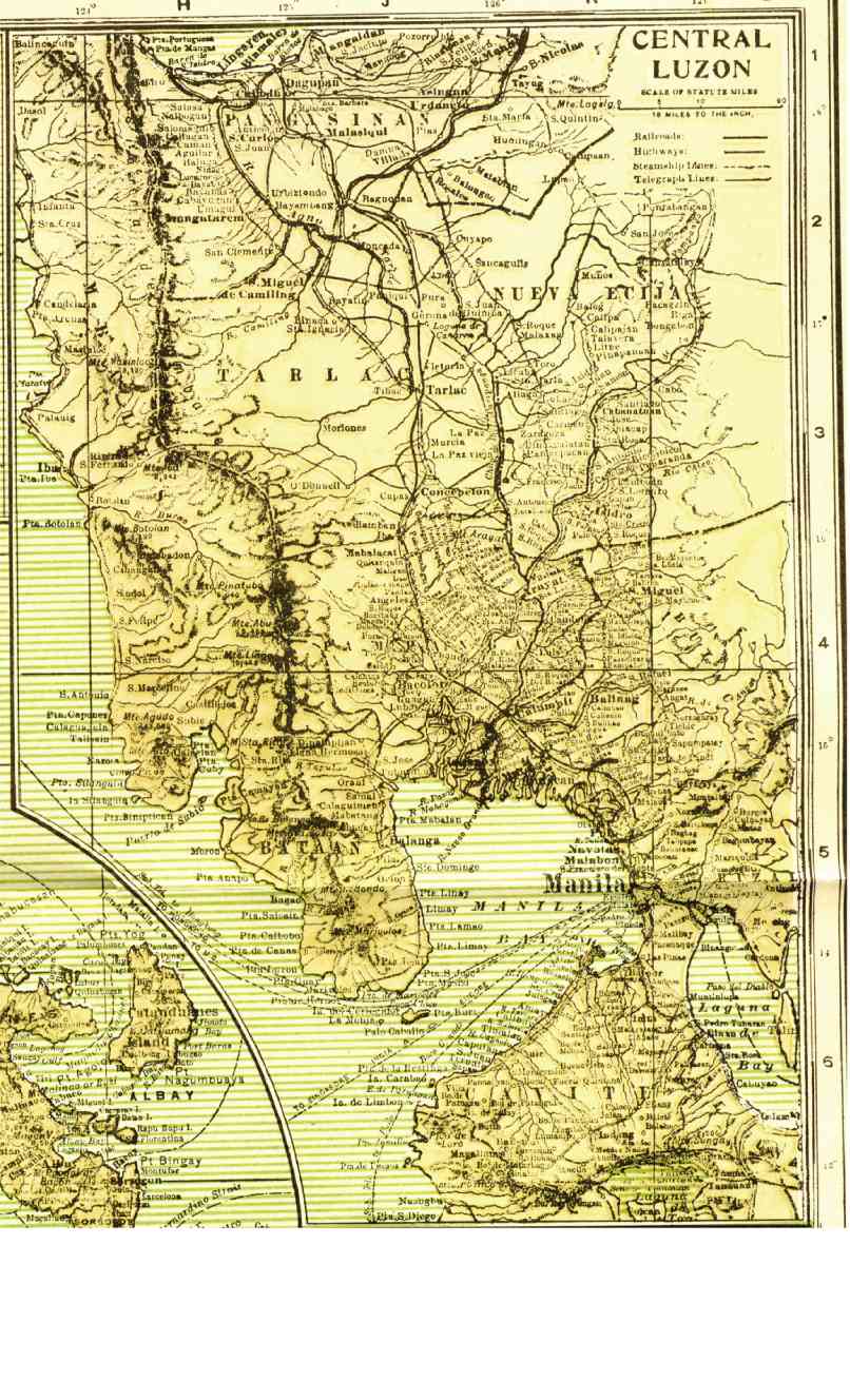
Map shows path of water from 30 major rivers in the region before it drains into Manila Bay
But the 300,000 residents living in 55 villages of Calumpit and the nearby town of Hagonoy seem to be resigned to live and cope with the yearly flooding that submerge their communities in 0.33 m to 3.07 m of water.
On Tuesday, 13 villages in Calumpit remained under 0.93 m of water while three villages in Hagonoy were under 0.63 m of water.
The towns of Calumpit, Hagonoy, San Ildefonso and San Miguel remain under a state of calamity due to the heavy flooding.
De Jesus lamented the national government’s response to their situation: “They tell us they are studying the situation. If they listened to us early on, then the problem would not have worsened.”
He said he believed the only solution to the perennial flooding in Calumpit and Hagonoy is the widening and dredging of rivers.
Bulacan Gov. Wilhelmino Sy-Alvarado said the Gatbuca River near his house in Calumpit used to be 1.2 to 1.5 m deep but siltation caused its level to drop to 0.3 m.
Other than dredging and widening of silted waterways, there is a more urgent need to build small dams in northern Bulacan, including the Candaba Swamp area in Pampanga, and the conversion of Bayabas River into a dam to contain floodwater, he said.
Decades-old problem
Flooding is a problem tackled in Pampanga and Bulacan since the American colonial period, said Pampanga Board Member Nestor Tolentino, a former supervising engineer of the defunct Pampanga River Control System (PRCS).
The Arnedo Dike, made of earth and spanning 17 km from Arayat to Apalit towns, was built in 1935 to confine the water draining from upstream.
By 1960, the government built a setback levee parallel to the Arnedo Dike as a second line of defense.
In 1978, the government unveiled the PDDP with support from the United Nations. The first component entailed widening and dredging the mouth of the river. The other component redirected the flow of the San Antonio River to the Cong Dadong Dam to irrigate around 10,000 hectares.
By 1995, the PRCS was shut down as project management offices responding to the Mt. Pinatubo disaster in 1991 had their respective flood control component.
The solutions now, Tolentino said, are regular dredging downstream to hasten the flow of water into Manila Bay, and to armor with steel and concrete at least 31 km of the setback levee from Arayat to Masantol.
The San Antonio Swamp in Nueva Ecija and the Candaba Swamp in eastern Pampanga and Bulacan are proposed to be reclaimed as water retarding ponds, Antonio Molano Jr., director of the Department of Public Works and Highways in Central Luzon, said citing an initial World Bank study.
The PDDP 2 has been revived and integrated in a P5-billion flood control project for Metro Manila and Central Luzon, Molano said. At least 2 km of the Labangan Channel have been dredged at a cost of P100 million.
But engineering interventions are not enough to minimize the risks of flooding, according to geologists Dr. Kelvin Rodolfo and Dr. Fernando Siringan.
In a paper published in 2006, they said groundwater extraction should be slowed down and regulated to curtail subsidence that worsens flooding.
“Unlike an earthquake or volcanic eruption, the worsening floods are gradual and permit temporary, stopgap solutions. Optimism is rampant during the flood-free half of the year when people want to forget the wet and discomfort,” they said.
“For the better-known causes of flooding, the answers are also well understood, easily stated and difficult to implement. The nation must stop using waterways as garbage dumps and housing sites. Original channel widths must be restored where [these are] illegally choked by fishponds.”


