


Expect heavy to intense rains in Luzon–Pagasa
SCREENGRAB FROM PAGASA.GOV.PH
The state weather bureau on Saturday warned of possible heavy to intense rainfall for over 24 hours in a wide swath of Luzon, which makes up northern Philippines, due to Typhoon Lando (international name Koppu).
“Based on our latest forecast models, it could go beyond 24 hours,” said Esperanza Cayanan, weather division chief of the Philippine Atmospheric Geophysical and Astronomical Services Administration.
READ: Palace: LGUs in northern PH ready for ‘Lando’ | Typhoon Lando slightly gains strength, nears landfall in Aurora | Flights cancelled, passengers stranded as Typhoon Lando nears
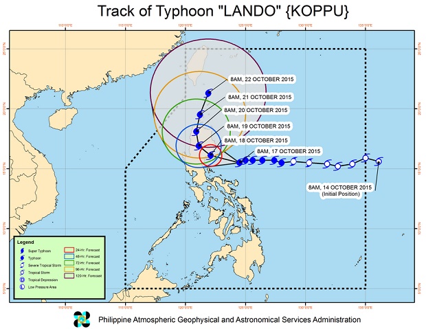
President Benigno Aquino III said on Friday that heavy rains are expected in almost the whole Luzon for six to 12 hours due to the slow-moving Lando, which is restricted by Typhoon Champi in the western Pacific.
Lando has a 600 kilometer radius.
Cayanan said continuous rains would bring damaging floods and landslides.
International weather websites have also expressed alarm over the huge amount of rain the typhoon is likely to spawn in the coming days.
Dr. Jeff Masters of the weather service Wunderground, said the typhoon might cause “widespread damaging flooding capable of causing a top-five most expensive disaster in Philippine history.”
Accuweather earlier said that Lando might bring “life-threatening flooding from days of torrential rainfall.”
The typhoon packed maximum sustained winds of 160 kilometers per hour and gusts of up to 195 kph. Cayanan said Lando may reach a peak of 185 kph of maximum sustained winds.
After landfall, which is expected early Sunday in Aurora, it will move slowly in Luzon because of Champi and exit the Philippine area of responsibility on Tuesday. This means Lando has plenty of time to pummel Luzon with its heavy to intense rains.
The typhoon is currently crawling at 10 kph westward.
Cayanan said that Lando was being restricted by Typhoon Champi and compared it to Typhoon Pepeng in 2009. Typhoon Quedan lingered in the country for days because it was being pulled back by Pepeng.
Public storm warning Signal No. 3 was raised over Aurora, Isabela, Quirino, Nueva Vizcaya, Nueva Ecija, Ifugao and Northern Quezon including Polillo Islands.
Signal No. 2 was raised over Cagayan including Calayan and Babuyan group of Islands, Benguet, Mt. Province, Abra, Kalinga, Apayao, Pangasinan, La Union, Ilocos Sur, Ilocos Norte, Bulacan, Pampanga, Tarlac, Rizal, rest of Quezon, Camarines Norte and Catanduanes.
Signal No. 1 was raised over Batanes, Zambales, Bataan, Cavite, Laguna, Batangas, Albay, Camarines Sur and Metro Manila.
Storm surges of 14 meters at open sea and two meters at coastal areas because of Lando.
Most typhoons make landfall during the -ber months due to the prevailing high pressure area, which keeps them from moving farther. CDG


