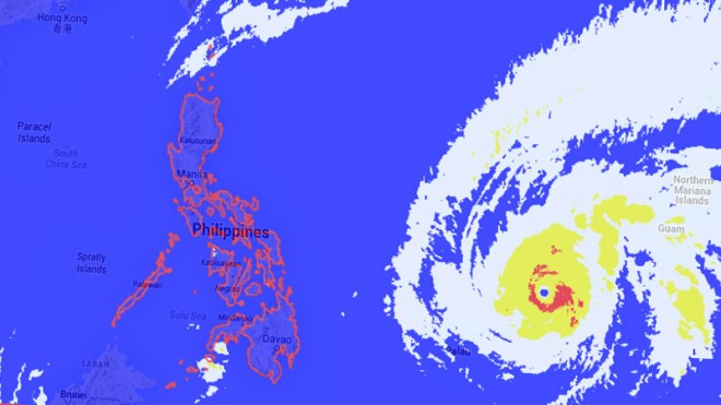
Supertyphoon threatens PH
A powerful typhoon that destroyed homes in Micronesia is moving straight to the Philippines and is expected to make landfall in Luzon on Easter Sunday, typhoon tracks plotted by several countries in the Asia-Pacific showed.
The National Weather Service on the island of Chuuk, part of the Federated States of Micronesia (FSM), said on Tuesday afternoon that Typhoon “Maysak’’ was expected to hit the Philippines on Sunday or Monday.
“Its official track shows it’s headed straight toward Luzon,” meteorologist Derek Williams said.
Malacañang assured the public that “all hands are on deck,” including President Benigno Aquino III, as the typhoon threatens to hit the country.
“As far as the government is concerned, as far as the President is concerned, all hands are on deck, (as) with any expected or unforeseen situations, incidents that may arise during Holy Week,” presidential spokesperson Edwin Lacierda said in a Palace briefing.
Lacierda said the National Disaster Risk Reduction and Management Council (NDRRMC) and the Philippine Atmospheric, Geophysical and Astronomical Services Administration (Pagasa) are both expected to provide “timely warnings” on the incoming typhoon.
“At the same time, the NDRRMC is, as you know, is composed of several Cabinet agencies, so all of them have already been informed of the incoming storm and insofar as the roles of each Cabinet agency, they know what to do,” Lacierda said.
Interior Secretary Mar Roxas urged local officials in the Visayas and southern Luzon to prepare for the expected entry of Maysak.
“Our mayors are the first responders. They should man the command centers in their respective localities,” said Roxas, vice chair of the NDRRMC.
“Even if the typhoon is still far off, our leaders should be ready for its possible onslaught,” he said.
Moving west northwest
The typhoon, which will be called “Chedeng” in the Philippines, is forecast to enter the Philippine area of responsibility (PAR) on Wednesday.
As of Tuesday, Maysak packed maximum sustained winds of 175 kilometers per hour (kph) and gusts of up to 210 kph while about 1,700 km east of Northern Mindanao. The typhoon is expected to move west northwest at 20 kph.
A cyclone is considered a supertyphoon when its sustained winds reach at least 220 kph, according to Pagasa.


