Storm brewing Mindanao
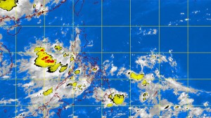
MANILA, Philippines–The weather bureau is monitoring a low pressure area (LPA) east of Mindanao although it is still well outside the Philippine area of responsibility (PAR).
Philippine Atmospheric, Geophysical and Astronomical Services Administration (Pagasa) forecasters expect the potential tropical cyclone to enter the PAR but said it might not go near the country’s landmass based on its current projected track.
Forecaster Glaiza Escullar said the LPA is over the Pacific Ocean near the Caroline Islands, an archipelago in the western Pacific Ocean north of New Guinea, and is still far from the PAR.
“It will not affect any part of the country because it is still too far. It could enter the PAR in a few days but, based on its current track, might not go near our landmass,” she said.
In Pagasa’s forecast for Friday, the habagat, or southwest monsoon, affecting the western sections of Luzon and the Visayas is expected to bring occasional rains to Metro Manila, the regions of Ilocos, Mimaropa (Mindoro-Marinduque-Romblon-Palawan), Calabarzon (Cavite-Laguna-Batangas-Rizal-Quezon) and the Western Visayas as well as the provinces of Bataan and Zambales.
The rest of the country will be partly cloudy to cloudy with isolated rain showers or thunderstorms.
Moderate to strong winds are expected to prevail over Luzon and the Western Visayas, where coastal waters will be moderate to rough. Light to moderate winds will prevail over the rest of the Visayas and Mindanao with slight to moderate seas.


