Intense rain to trigger lahar, mudflows along Mt. Mayon—Phivolcs

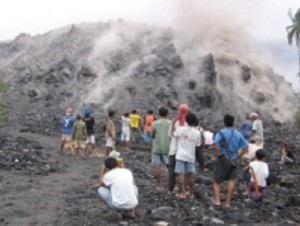
Residents living near Mayon Volcano take a closer look at the lava in Barangay Mabinit, Legazpi City. INQUIRER FILE PHOTO
LEGAZPI CITY, Philippines — The Philippine Institute of Volcanology and Seismology (Phivolcs) warned thousands of villagers living along river channels surrounding the slopes of Mt. Mayon volcano of severe lahar flows and landslides due to heavy rains to be spawned by supertyphoon “Yolanda” (international name: Haiyan) that might hit Bicol on Friday.
Alex Baloloy, Phivolcs resident volcanologist, told members of the Regional Disaster Risk Reduction and Management Council (RDRRMC) that millions of cubic meters of lahar would threaten downstream communities along river channels bordering the slopes of the 2,463-meter high volcano in Albay.
He said that the projected 10 millimeter-to-30-mm of rains that would pelt the province every hour could dislodge the lahar deposits and pyroclastic materials deposited along river channels and threaten communities living along these river channels.
Albay Governor Joey Salceda said 22,622 families or 103,193 persons in the towns of Malilipot, Bacacay, Sto. Domingo, Daraga, Camalig, Guinobatan and the cities of Ligao and Legazpi would be affected by lahar mudflows.
He said the provincial government has started evacuating people along these areas threatened by mud flows and lahar.
Salceda said 165 barangay (villages) would likely be hit by landslides and 67 would likely be affected by mudflows or lahar flows.
He said 484 villages in Albay with 299,396 persons living in flood-prone areas could be affected by floods.
Baloloy said extreme rainfall might trigger landslides and excessive erosion of old pyroclastic deposits in the slopes of Mayon volacano.
He said the river channels silted with lahar are Masarawag, Maninila in Guinobatan; Buyuan, Padang and Mabinit in Legazpi City; Lidong and Basud in Sto Domingo; Miisi, Anoling in Daraga and Nabonton channels in Ligao City.
Baloloy said debris flows during heavy rain might trigger landslides in Mt. Masaraga, an old volcanic edifice north of Mayon volcano, and might cascade down the Gabon river and other streams, threatening the town of Polangui, similar to what happened on July 11, 2011, during tropical storm Juaning.
Phivolcs recommended the pre-emptive evacuation of communities in zones at “high-risk” to lahar hazards in Mt. Mayon for the duration of the passage of supertyphoon Yolanda.
RELATED STORIES:
Mass evacuations ahead of Supertyphoon ‘Yolanda’