Pagasa: Storm too far
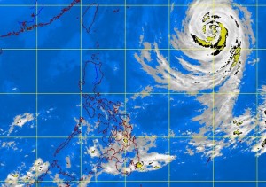
MANILA, Philippines—Typhoon “Francisco” may linger until Thursday within the Philippine area of responsibility (PAR) as it passes through on its way to Japan.
Philippine Atmospheric, Geophysical and Astronomical Services Administration (Pagasa) forecasters said that although Francisco, which will be renamed “Urduja” when it enters the PAR on Tuesday, will not get near enough to have any effect on the country and generally good weather is expected to continue.
Forecaster Joey Figuracion said they anticipate Francisco will hover in the PAR until Thursday afternoon or evening.
Figuracion said that as of 4 p.m. Monday, Francisco’s eye was estimated at 1,330 kilometers east of extreme northern Luzon with maximum sustained winds of 160 kilometers per hour and gustiness of up to 195 kph moving north northwest at 11 kph.
He said the tropical cyclone posed no threat to the country because of its distance and generally good weather will continue to prevail, particularly in Metro Manila, Central Luzon, as well as the Ilocos, Cordillera and Cagayan Valley where partly cloudy to cloudy skies are anticipated on Tuesday with isolated light rains.—Jeannette I. Andrade


