Typhoon ‘Mina’ threatens N. Luzon; Signal No. 1 up–Pagasa
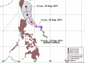
MANILA, Philippines — Signal no. 1 was raised in some areas of Luzon as tropical cyclone “Mina” (international name Nanmadol) has intensified into a typhoon and now threatens Northern Luzon, the Philippine Atmospheric Geophysical and Astronomical Services Administration (Pagasa) said Thursday.
In its latest weather forecast issued at 11 a.m., Pagasa said that Signal No. 1 was over Northern Aurora, Isabela and Cagayan.
Mina was seen 310 kilometers east of Casiguran Aurora and was packing maximum sustained winds of 120 kilometers per hour near the center and gusts of up to 150 kph.
The typhoon is now moving 7 km west-northwestward.
Residents living in low-lying and mountainous areas are warned against possible flashfloods and landslide, Pagasa said.
Mina was forecast to enhance the southwest monsoon and bring scattered to widespread rains over the western section of Southern Luzon and Visayas.
Estimated rainfall is 15 to 25 millimeters per hour within 500 km diameter of Mina, Pagasa added.
By Friday morning, Mina is expected to be 220 km northeast of Casiguran, Aurora.
By Saturday morning, the typhoon is forecast to be 260 km north northeast of Tuguegarao City or 100 km southeast of Basco, Batanes and by Sunday morning, Mina will be 200 km north-northeast of Basco, Batanes, Pagasa said.


