


Storm ‘Mina’ intensifies
Tropical Storm “Mina’’ slightly intensified on Wednesday, while remaining stationary over Philippine Sea northeast of the archipelago.
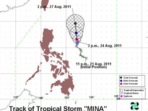
MANILA, Philippines—Tropical Storm “Mina’’ slightly intensified on Wednesday, while remaining stationary over Philippine Sea northeast of the archipelago.
The storm is expected to enhance southwest monsoon to bring rain over the southern part of Luzon, Visayas and Mindanao, said the Philippine Atmospheric Geophysical and Astronomical Services Administration.
“These areas will experience light to moderate rain,’’ forecaster Jun Galang said by phone.
The rest of Luzon, however, would experience mostly cloudy skies with scattered rainshowers and thunderstorms, Pagasa said.
The rains would become widespread over the eastern section of Northern and Central Luzon, which may trigger flashfloods and landslides.
These areas will experience moderate to heavy rain, according to Galang.
Mina, packing maximum sustained winds of 85 kilometers per hour and gustiness up to 100 kph, was spotted over Philippine Sea 400 km northeast of Virac, Catanduanes, at around 4 p.m. Wednesday.
Since it remained stationary over Philippine Sea, Mina could either intensify into a typhoon or move in another direction, Galang said.
Mina was the first cyclone to enter the Philippine area of responsibility in August, when two to three cyclones are expected to hit the country.


