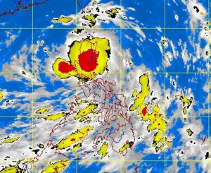
‘Labuyo’ to exit PH Monday, says Pagasa
MANILA, Philippines – After it lashed out Luzon, typhoon “Labuyo” (international name: Utor) further weakened and will exit the Philippine territory Monday afternoon, the state weather bureau said.
“Labuyo” with maximum sustained winds of 140 kilometers per hour near the center and gusts of up to 170 kilometers per hour was last observed in the vicinity of Baguio City at 10a.m, the Philippine Atmospheric Geophysical and Astronomical Services Administration said.
Signal No. 3 (101-185 kph winds) remained hoisted in the following areas: Quirino Nueva Vizcaya, Ifugao, Mt. Province, Ilocos Sur, Benguet, La Union and Pangasinan.
Travel is very risky especially by sea and air under Signal No. 3. Disaster preparedness and response agencies/organizations are in action with appropriate response to actual emergency.
Pagasa said there might be widespread disruption of electrical power and communication services under this storm signal. In general, moderate to heavy damage might be experienced, particularly in the agricultural and industrial sectors.
Signal No. 2 (61-100kph winds), meanwhile, was hoisted in the following areas: Isabela, Aurora, Southern Cagayan, Kalinga, Abra, Southern Ilocos Norte, Zambales, Tarlac and Nueva Ecija
In areas under this storm signal, the winds might bring light to moderate damage to the exposed communities. Disaster preparedness agencies / organizations are in action to alert their communities.
Signal No. 1 (45-60kph winds) was raised in the following areas: Rest of Cagayan, Apayao, Rest of Ilocos Norte, Babuyan and Calayan Group, Pampanga, Bulacan, Bataan, Rizal, Northern Quezon including Polillo Island, and Metro Manila.
Under this storm signal, only very light or no damage at all might be sustained by the exposed communities. Disaster preparedness is activated to alert status.
Public storm signals elsewhere are now lowered, Pagasa said.
Labuyo moved west northwest at 19 kph, and was expected to be at 360 kilometers west of Sinait, Ilocos Sur by Tuesday morning.
It will bring moderate to heavy rains within its 500 km diameter and will enhance the southwest monsoon, which will bring moderate to occasionally heavy rains over Southern Luzon and Western Visayas, Pagasa said.
Residents in areas with storm signals were alerted of flashfloods and landslides, while areas under Signal No. 3 and 2 were alerted against storm surges.
Fishermen especially those using small seacraft were advised not to venture out into the western and southern seaboards of Southern Luzon and the seaboards of Visayas due to big waves generated by “Labuyo.”


