Storm signals up for ‘Labuyo’
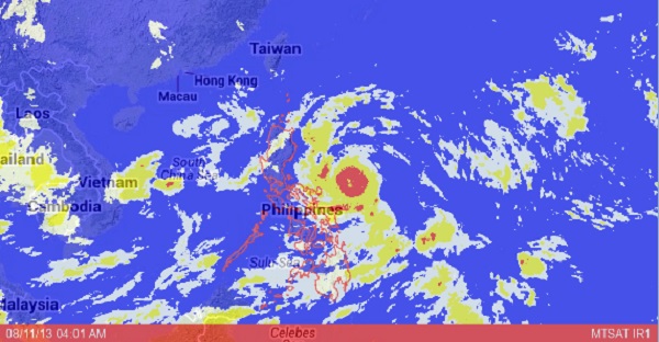
MANILA, Philippines—Tropical depression “Labuyo” gained strength and turned into a storm on Saturday as it approached the country, prompting the state weather bureau to hoist storm signals over parts of Luzon.
As of noon Saturday, the eye of the storm was observed some 570 kilometers east of Virac, Catanduanes, packing peak winds of 85 kilometers per hour and gustiness of 100 kph, forecasters said.
The Philippine Atmospheric, Geophysical and Astronomical Services Administration (Pagasa) predicted Labuyo to move west northwest at 19 kph.
Public storm signal No. 1, indicating 45-60 kph winds, was raised over Cagayan, Isabela, Aurora, Quirino, and Catanduanes.
Moderate to intense rains falling at a rate of 5-16 millimeters per hour are expected within the 400-kilometer diameter of the storm, Pagasa said.
In an advisory, the weather bureau said the storm would exit the Philippine territory on Tuesday morning.
Palawan, Mindoro, Aurora, Rizal, Agusan Del Sur and Compostela Valley will experience cloudy skies with light to moderate rain showers and thunderstroms, Pagasa said in its 24-hour weather outlook.
Metro Manila and the rest of the country will be partly cloudy to cloudy with isolated rain showers or thunderstorms, it added.
Light to moderate winds blowing from the southwest to southeast will prevail over Southern Luzon, Visayas and Mindanao, and winds coming from southeast to east over the rest of Luzon, Pagasa said.


