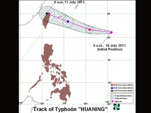
Storm signals up in more NL areas as ‘Huaning’ heads to Taiwan
MANILA, Philippines–The state weather bureau raised storm signals in more areas in extreme Northern Luzon Friday as Typhoon Huaning maintained its intensity heading towards Taiwan.
Signal No. 2, indicating wind speeds of 61-100 kilometers per hour, was up over the Batanes group of islands, while Signal No. 1 was hoisted over the Calayan and Babuyan groups of islands.
As of 5 p.m. Friday, the eye of the typhoon with the international name Soulik was observed some 360 kilometers northwest of Itbayat, Batanes, the Philippine Atmospheric, Geophysical and Astronomical Services Administration (Pagasa) said.
Huaning was packing peak winds of 165 kph near the center and gustiness of up to 200 kph. It is predicted to move west northwest at 20 kph, Pagasa said.
By Saturday morning, the typhoon is forecast to have left the Philippine area of responsibility.
Although it won’t make landfall in the country, the storm will spawn rains falling at 4 – 22 mm per hour (moderate-intense) within its 900-kilometer diameter, Pagasa said.
Fishermen, specially those using small seacraft, were advised not to venture out into the northern and eastern seaboards of Luzon due to big waves generated by the typhoon.


