


CDO, Iligan disaster seen in Ilocos
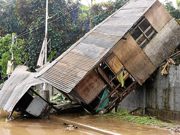
A HOUSE in Cagayan de Oro City after Tropical Storm “Sendong” unleashed its fury. Experts say a similar natural disaster could happen in Ilocos Norte. INQUIRER file photo
LAOAG CITY, Philippines—An environment official said the devastating floods that struck Northern Mindanao last month could happen in this city and outlying towns because of their topography.
Juan de los Reyes, provincial environment and natural resources officer, said flood mapping conducted by the University of the Philippines’ National Institute of Geological Sciences (UP-NIGS) is closely similar to a geohazard mapping that the Environmental Management Bureau (EMB) prepared for the Ilocos region.
Based on the study of UP geologists, Ilocos cities that include Laoag, Vigan and Alaminos are vulnerable to disastrous floods because their topography is similar to Iligan and Cagayan de Oro cities.
In its website (www.nababaha.com), the UP-NIGS flood hazard mapping showed low to high flood risks in some villages in Laoag that run parallel to the Padsan River.
Similar flood intensities, ranging from 0.1 to 1.5 meters deep, were noted in neighboring Bacarra town where villages straddle the Bislak River.
UP geologists used flood simulations using rainfall dumped by Tropical Storm “Ondoy” in September 2009. Using the “FLO-2D” or a Federal Emergency Management Agency-approved flood-routing application software, the UP-NIGS came out with flood hazard maps to alert local governments on how they could chart local emergency response and urban planning.
“These hazard maps are indicative inundation maps for large flood events and useful only for knowing where not to be during extremely heavy rainfall. These hazard maps are only as good as the topographic map base that was used in the flood simulation,” the UP-NIGS website said.
De los Reyes said a geohazard map that the EMB prepared showed that the Laoag villages of La Paz, Tanguid, San Joaquin, San Leonardo and San Antonio are susceptible to flooding. Other towns with similar condition include Piddig, Solsona, Dingras, Marcos, Bangui and Dumalneg.
“Being low-lying areas, surface water runoff automatically drains into these towns while excess water flows there before it finally exits to the sea,” he said.
He also said silted rivers and creeks contribute to flooding.
The Department of Environment and Natural Resources has issued hazard maps to local governments to prepare them before the typhoon season sets in.
The maps contain a list of towns susceptible to flooding and landslides and include tips on disaster-preparedness and names and contact numbers of authorities who residents could ask for help.
“What is important is dry-running for actual disasters. We need people to be informed now because disasters could happen in unexpected moments,” De los Reyes said.
He, however, said disaster-preparedness is merely a quick remedy. He said the long-term solution is forest rehabilitation.
“The National Greening Program will revive our forests and mountains which have been destroyed due to illegal logging,” he said.
The program was made a policy under Executive Order No. 26 that President Aquino signed on Feb. 24, 2011.
Under the program, at least 1.5 billion seedlings in 1.5 million hectares in the country should have been planted from 2011 to 2016.


