


What Went Before: Landslides in Compostela Valley
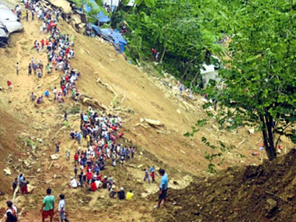
This photo released by the Philippine Army shows the extent of Thursday’s landslide that hit the small-scale mining community of Pantukan in Compostela Valley. The landslide buried dozens of people months after government officials warned miners that the mountain above them was guaranteed to crumble. PHOTO COURTESY OF 10TH INFANTRY DIVISION, PHILIPPINE ARMY
A spate of landslides has claimed many lives in Pantukan town in Compostela Valley in recent years.
On May 18, 2009, at least 27 people, mostly miners, were killed and 18 others were injured when days of heavy rain triggered a landslide at Sitio (sub-village) Mangapispis in Barangay (village) Napnapan and nearby villages.
Officials were told by residents that a sudden “buhawi” (cloudburst) hit the uppermost community, demolishing 30 shanties and a house.
On April 22, 2011, nonstop rains induced another landslide at Sitio Panganason in Barangay Kingking. Thirteen people were killed.
In August last year, three small-scale miners were killed in a landslide that hit a mining area in New Bataan town. Another landslide killed five people in Barangay Diwalwal in Monkayo town last December.
Following the April disaster, Governor Arturo Uy ordered a 30-day halt in all mining operations in the gold-rich areas of the province. Residents of nearby areas were forced to evacuate for safety reasons.
Monitoring, control system
Manila Auxiliary Bishop Broderick Pabillo called for a moratorium on all mining operations until an efficient monitoring and control system had been put in place.
But the director of the Mines and Geosciences Bureau (MGB), Leo Jasareno, said this was a disproportionate reaction to the landslide. He emphasized that the problem was illegal small-scale mining, not the mining industry in itself.
In May, the MGB directed a team of geologists to conduct a detailed geohazard mapping of Compostela and Pantukan towns. When it released its findings in July, the team attributed the big landslide casualties to the unregulated influx of small-scale miners to the areas.
They found that the landslides in Pantukan occurred in areas close to road projects and mining sites while those in Compostela happened along new road cuts.
At least six areas in Barangay Napnapan and Sitio Panganason in Barangay Kingking were identified as highly susceptible to landslides.
The study asked local officials to strictly enforce land-use plans and regulate the construction of ball mills and tailing ponds to prevent the overloading of slopes and seepage that could trigger landslides. Lawrence de Guzman, Inquirer Research; with a report from Germelina Lacorte, Inquirer Mindanao
Sources: Inquirer Archives


