


Nondescript rock marks PH navel
MOGPOG, MARINDUQUE—Atop the 220-meter Mataas na Bundok in the sleepy village of Hinanggayon here, a seemingly ordinary rock juts out like a sore thumb from grassy ground at a minipark overlooking Tayabas Bay.
Geodetic engineers, it is said, must make the arduous trek to this area, known as Station Balanacan, at least once in their lifetime, to see the rock and imbibe its value to their profession.
“It has become like a custom before you can call yourself a geodetic engineer, simply because it’s the geodetic center [of the country],” said Roman Legaspi, chief of the surveys and mapping division of the Department of Environment and Natural Resources (DENR) in Mimaropa (Mindoro, Marinduque, Romblon, Palawan) region.
Station Balanacan, one of the triangulation stations established by the US Coast and Geodetic Survey (USCGS) between 1901 and 1911, is also called the Luzon Datum of 1911. It marks the geodetic center of the Philippines, meaning all maps and geological surveys done in the country are referenced to this (0,0) point.
But to people of the fishing village of Hinanggayon, playing host to the country’s navel is a source of pride and livelihood.
“Whenever I go to Manila, a lot of people are asking where it is (Luzon Datum) and I’m happy to say that it’s located in our place,” said Merly Mangana, a 57-year-old resident.


PRECIOUS ROCK This minipark in Mogpog, Marinduque, hosts the Luzon Datum, the most important rock in the country’s geological surveys. —PHOTOS BY RICHARD REYES
Hard rock
Past Our Lady of Peace and Good Voyage Parish church at Barangay Balanacan, a 10-kilometer drive up a winding road of alternating concrete, asphalt and gravel leads to the base of the hill.
About 300 concrete steps up, lined with handrails, is the Luzon Datum, an oddly shaped rock measuring 30.48 centimeters in diameter and 80 cm high from the base.
Experts simply call it “hard rock” and never dug to find out how much deep it is buried for fear of “disturbing” the coordinates of its position.
“There isn’t any study, though, [on what type it is],” Legaspi said. The rock looks very much the same as it did in 1911, he swore, citing records in his office.
According to a geologist who examined a photograph of the Luzon Datum, it is diorite, an igneous rock characterized by its “salt and pepper” look and which usually hosts copper mineralization.
The USCGS drilled a hole 6-cm deep (1.5 cm in diameter) into the rock’s smooth surface that geodetic engineers today use not only to calculate coordinates but also to mount surveying instruments.
Community-based
Community elders have shared stories about the time the Americans first arrived in Marinduque with “gadgets” and measuring tools. Mangana said the villagers were hired to help carry the equipment.
People began to believe there was gold up the hill. There was no real treasure, as it turned out, but the community today starts to benefit from the nondescript rock.
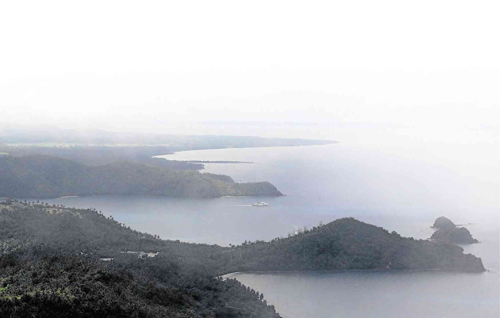
REWARD Tourists are rewarded with a view of Marinduque’s coastline after an exhausting climb to Station Balanacan on Mataas na Bundok.
On Aug. 9, 2011, the government unveiled a historical marker in celebration of the centennial commemoration of the establishment of the Luzon Datum.
Then President Benigno Aquino III proclaimed an area of 281,817 square meters in the villages of Hinanggayon and Argao as the Luzon Datum Origin national historical landmark and ecotourism site, and placed its stewardship under the DENR, the National Mapping and Resource Information Authority, and the provincial government.
“After they put the marker, people started coming in,” Mangana said. Most tourists visit during Moriones, a traditional religious rite observed during the Holy Week in Marinduque.
In 2015, the local government helped organize the community-based Luzon Datum Producers Cooperative, which Mangana currently heads. The group counts more than 100 members, mostly women, from Hinanggayon, Argao and Silangan.
Tourist draw
Old-timers love to describe Marinduque as the “puso” (heart) or “pusod” (navel) of the Philippines, due to its shape and location.
“If you look at the [Philippine] map, it’s as if [Marinduque] is at the bosom. Plus, if you look closely at the [island], it’s shaped like a heart,” said Dindo Asuncion, provincial tourism officer.
The Luzon Datum strengthens the province’s claim that it is the “heart” of the archipelago. “I don’t know if you can call it happenstance but that’s how we’d like to believe it—it’s fated,” Asuncion said.
The community-based program earns from fees (P50 per head) it collects for a guided tour to the Luzon Datum. From the hilltop, tourists spend time scanning the view of Tayabas Bay and the surrounding islets.
“Sunrise and sunsets are the best time [to climb],” Mangana said.
On regular days, she said, the cooperative would earn about P500 a month and about P1,000 during summer and the Moriones week. The funds are divided among members or used to keep the place clean and fix the steps or the pergola damaged by storms in previous years.
The government has also begun constructing a road.
“I don’t think we’re going to have a road here if not for [the Luzon Datum]. We’re lucky,” Mangana said.
Asuncion said the Luzon Datum was just one of the local government’s community-based projects. “[That’s because people] know the place better than anyone else,” he said.
In keeping with Marinduque’s brand as a Catholic tourist destination, the province plans to install Stations of the Cross near the Luzon Datum.
Another is to build a shrine, resembling Bulacan’s popular pilgrim site of Mama Piat in Doña Remedios Trinidad town, with an image of the Virgin Mary rising nowhere else but at the heart of the Philippines.


